1960s Maps of Wauseon, Ohio
Explore 2 historic maps of Wauseon from the 1960s. These maps offer a rare glimpse into what life looked like during the 1960s — showing old roads, neighborhoods, homes, and landmarks that have changed or disappeared over time.
Whether you're researching your family's past, planning a metal detecting trip, or studying how Wauseon's landscape evolved across the 1960s, these high-resolution maps are a powerful tool for exploring the history of this region.
- Focus on a specific era: All maps on this page are from the 1960s, giving you a focused view of this time period.
- See what’s changed: Compare century-old streets, trails, and buildings to today's modern landscape using overlays and satellite layers.
- Research with precision: Use these maps for genealogy, historical research, land use analysis, or educational projects.
- View, download, or print: Maps are fully viewable online in high resolution, and can be downloaded or printed for your own records.
Start exploring Wauseon's history through authentic maps from the 1960s. This is your window into the past.
Wauseon, OH maps
(2)- 1960 Map of Wauseon, 1961 Print
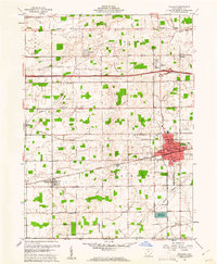 1960 Wauseon1961 Print · USGSFulton County agricultural life and mid-century transit are frozen in time just as the interstate era reshaped the landscape. Researchers can trace family sites like Aeschliman Cem, the old Ottokee Station, and local landmarks like the Drive-in Theater.3 unique versions available
 - 1960 Map of Delta, 1962 Print
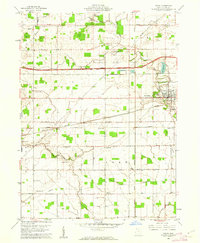 1960 Delta1962 Print · USGSThe rail and road networks of Fulton County are on full display during the early sixties, centered on the growing hub of Delta. Researchers can trace old family lines through Greenlawn Cemetery or locate rural landmarks like the Swan Creek Ch and Grieser Airport.3 unique versions available
End of results
Showing maps 1-2 of 2
Top cities near Wauseon
- Napoleon historical maps
- Archbold historical maps
- Delta historical maps
- Morenci historical maps
- Fayette historical maps
- Liberty Center historical maps
See more
Frequently asked questions
- What are the different types of historical maps available for Wauseon?
- What is the oldest map of Wauseon?
- Where can I purchase historical maps of Wauseon for my home or office?
- Where can I download high-res historical maps of Wauseon?
- Are there historical topographic maps available for Wauseon?
- Is there historical aerial imagery available for Wauseon?
- Where are historical maps of Wauseon sourced from?