1900s (20th Century) Maps of Burton Township, Ohio
Explore 21 historic maps of Burton Township from the 1900s (20th Century). These maps offer a rare glimpse into what life looked like during the 1900s — showing old roads, neighborhoods, homes, and landmarks that have changed or disappeared over time.
Whether you're researching your family's past, planning a metal detecting trip, or studying how Burton Township's landscape evolved across the 1900s, these high-resolution maps are a powerful tool for exploring the history of this region.
- Focus on a specific era: All maps on this page are from the 1900s, giving you a focused view of this time period.
- See what’s changed: Compare century-old streets, trails, and buildings to today's modern landscape using overlays and satellite layers.
- Research with precision: Use these maps for genealogy, historical research, land use analysis, or educational projects.
- View, download, or print: Maps are fully viewable online in high resolution, and can be downloaded or printed for your own records.
Start exploring Burton Township's history through authentic maps from the 1900s. This is your window into the past.
Burton Township, OH maps
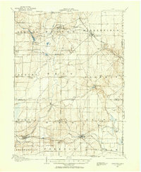
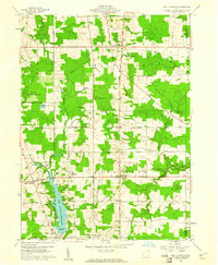
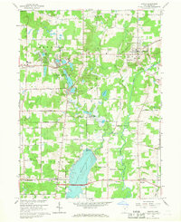
(21)- 1904 Map of Chardon, 1962 Print
 1904 Chardon1962 Print · USGSCovers Burton Township, including Painesville, Chardon, and other nearby areas
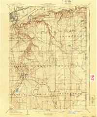
 - 1905 Map of Garrettsville, 1958 Print
 1905 Garrettsville1958 Print · USGSCovers Burton Township, including Southington Township, Mesopotamia Township, and other nearby areas
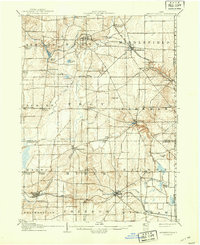
 - 1906 Map of Chardon, 1940 Print
 1906 Chardon1940 Print · USGSCovers Burton Township, including Painesville, Chardon, and other nearby areas2 unique versions available
 - 1907 Map of Garrettsville, 1943 Print
 1907 Garrettsville1943 Print · USGSCovers Burton Township, including Southington Township, Mesopotamia Township, and other nearby areas2 unique versions available
 - 1950 Map of Cleveland
 1950 Cleveland1950 Print · USGSCovers Burton Township, including Cleveland, Akron, and other nearby areas
 - 1953 Map of Chardon, 1954 Print
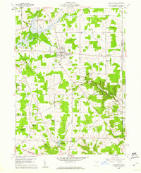
 1953 Chardon1954 Print · USGSCovers Burton Township, including Chardon, Hambden Township, and other nearby areas2 unique versions available
 - 1953 Map of Burton, 1955 Print
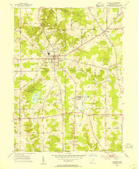
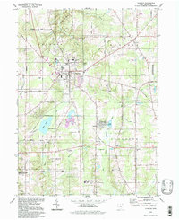
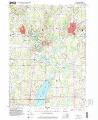
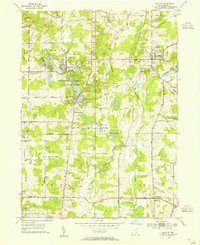 1953 Burton1955 Print · USGSCovers Burton Township, including Burton Village, Welshfield, and other nearby areas2 unique versions available
 - 1956 Map of Cleveland, 1967 Print
 1956 Cleveland1967 Print · USGSCovers Burton Township, including Cleveland, Akron, and other nearby areas3 unique versions available
 - 1959 Map of East Claridon, 1961 Print
 1959 East Claridon1961 Print · USGSCovers Burton Township, including Hambden Township, Mesopotamia Township, and other nearby areas3 unique versions available
 - 1959 Map of Middlefield, 1961 Print
 1959 Middlefield1961 Print · USGSCovers Burton Township, including Mesopotamia Township, Farmington Township, and other nearby areas3 unique versions available
 - 1962 Map of Cleveland
 1962 Cleveland1962 Print · USGSCovers Burton Township, including Cleveland, Akron, and other nearby areas
 - 1966 Map of Chardon, 1968 Print
 1966 Chardon1968 Print · USGSCovers Burton Township, including Chardon, Hambden Township, and other nearby areas3 unique versions available
 - 1966 Map of Burton, 1968 Print
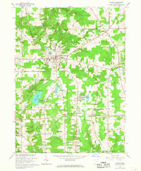
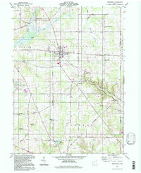
 1966 Burton1968 Print · USGSCovers Burton Township, including Burton Village, Welshfield, and other nearby areas2 unique versions available
 - 1985 Map of Cleveland North, 1986 Print
 1985 Cleveland North1986 Print · USGSCovers Burton Township, including Cleveland, Lakewood, and other nearby areas
 - 1986 Map of Cleveland South
 1986 Cleveland South1986 Print · USGSCovers Burton Township, including Cleveland, Akron, and other nearby areas
 - 1994 Map of Cleveland North
 1994 Cleveland North1994 Print · USGSCovers Burton Township, including Cleveland, Lakewood, and other nearby areas
 - 1994 Map of Cleveland South
 1994 Cleveland South1994 Print · USGSCovers Burton Township, including Cleveland, Akron, and other nearby areas
 - 1994 Map of Chardon, 1997 Print
 1994 Chardon1997 Print · USGSCovers Burton Township, including Chardon, Hambden Township, and other nearby areas
 - 1994 Map of Middlefield, 1997 Print
 1994 Middlefield1997 Print · USGSCovers Burton Township, including Mesopotamia Township, Farmington Township, and other nearby areas
 - 1994 Map of East Claridon, 1997 Print
 1994 East Claridon1997 Print · USGSCovers Burton Township, including Hambden Township, Mesopotamia Township, and other nearby areas
 - 1994 Map of Burton, 2000 Print
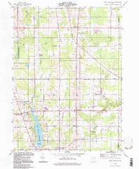
 1994 Burton2000 Print · USGSCovers Burton Township, including Burton Village, Welshfield, and other nearby areas
End of results
Showing maps 1-21 of 21
Top cities near Burton Township
- Mentor historical maps
- Willoughby historical maps
- Streetsboro historical maps
- Aurora historical maps
- Kirtland historical maps
- Shalersville historical maps
See more
Top neighborhoods of Burton Township
- Burton Township historical maps
- Burton Station historical maps
- Burton Lake historical maps
- Burton Village historical maps
Frequently asked questions
- What are the different types of historical maps available for Burton Township?
- What is the oldest map of Burton Township?
- Where can I purchase historical maps of Burton Township for my home or office?
- Where can I download high-res historical maps of Burton Township?
- Are there historical topographic maps available for Burton Township?
- Is there historical aerial imagery available for Burton Township?
- Where are historical maps of Burton Township sourced from?