1950s Maps of Xenia Township, Ohio
Explore 4 historic maps of Xenia Township from the 1950s. These maps offer a rare glimpse into what life looked like during the 1950s — showing old roads, neighborhoods, homes, and landmarks that have changed or disappeared over time.
Whether you're researching your family's past, planning a metal detecting trip, or studying how Xenia Township's landscape evolved across the 1950s, these high-resolution maps are a powerful tool for exploring the history of this region.
- Focus on a specific era: All maps on this page are from the 1950s, giving you a focused view of this time period.
- See what’s changed: Compare century-old streets, trails, and buildings to today's modern landscape using overlays and satellite layers.
- Research with precision: Use these maps for genealogy, historical research, land use analysis, or educational projects.
- View, download, or print: Maps are fully viewable online in high resolution, and can be downloaded or printed for your own records.
Start exploring Xenia Township's history through authentic maps from the 1950s. This is your window into the past.
Xenia Township, OH maps
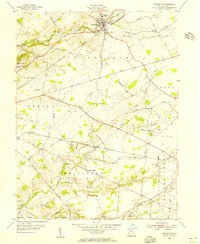
(4)- 1955 Map of New Burlington, 1956 Print
 1955 New Burlington1956 Print · USGSGreene and Clinton Counties are shown in the mid-1950s as a landscape of established townships and winding creek forks. Genealogists and local historians can trace family roots through numerous sites like New Burlington Cem, Richland Ch, and McKay Cem.2 unique versions available
 - 1955 Map of Yellow Springs, 1956 Print
 1955 Yellow Springs1956 Print · USGSMid-century Greene County centers on the academic and social landscape of Yellow Springs as it appeared in the mid-fifties. Local researchers can trace family landmarks and rural life at Antioch College, Pleasant Grove Ch, and the small settlement of Goes.2 unique versions available
 - 1955 Map of Cedarville, 1956 Print
 1955 Cedarville1956 Print · USGSGreene County in the mid-fifties is captured here as a busy intersection of rail lines and higher education. Genealogists and historians can trace the foundations of Central State College, the small community of New Jasper, and the grounds of Massies Creek Cem.2 unique versions available
 - 1955 Map of Xenia, 1956 Print
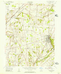
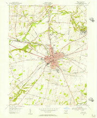 1955 Xenia1956 Print · USGSMid-century Greene County centers on the thriving rail crossroads of Xenia and the nearby academic hubs of Wilberforce. Genealogists and local historians can trace family plots at Woodland Cem or locate historic institutions like the Soldiers and Sailors Orphans Home.
End of results
Showing maps 1-4 of 4
Top cities near Xenia Township
- Dayton historical maps
- Springfield historical maps
- Kettering historical maps
- Beavercreek historical maps
- Huber Heights historical maps
- Fairborn historical maps
See more
Top neighborhoods of Xenia Township
- Monroe historical maps
- Wilberforce historical maps
- Goes Station historical maps
- Oldtown historical maps
Frequently asked questions
- What are the different types of historical maps available for Xenia Township?
- What is the oldest map of Xenia Township?
- Where can I purchase historical maps of Xenia Township for my home or office?
- Where can I download high-res historical maps of Xenia Township?
- Are there historical topographic maps available for Xenia Township?
- Is there historical aerial imagery available for Xenia Township?
- Where are historical maps of Xenia Township sourced from?