1990s Maps of College Hill, Ohio
Explore 2 historic maps of College Hill from the 1990s. These maps offer a rare glimpse into what life looked like during the 1990s — showing old roads, neighborhoods, homes, and landmarks that have changed or disappeared over time.
Whether you're researching your family's past, planning a metal detecting trip, or studying how College Hill's landscape evolved across the 1990s, these high-resolution maps are a powerful tool for exploring the history of this region.
- Focus on a specific era: All maps on this page are from the 1990s, giving you a focused view of this time period.
- See what’s changed: Compare century-old streets, trails, and buildings to today's modern landscape using overlays and satellite layers.
- Research with precision: Use these maps for genealogy, historical research, land use analysis, or educational projects.
- View, download, or print: Maps are fully viewable online in high resolution, and can be downloaded or printed for your own records.
Start exploring College Hill's history through authentic maps from the 1990s. This is your window into the past.
College Hill, OH maps
(2)- 1993 Map of Bloomfield
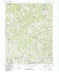 1993 Bloomfield1993 Print · USGSGuernsey County's rural landscape is captured here in the early nineties, showing a region defined by winding creek valleys and hilltop settlements. Researchers can trace family history through sites like Indian Camp, Northfield Cem, and the Mt Harmon Ch near the banks of Wills Creek Lake.
 - 1994 Map of Bloomfield, 1998 Print
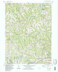 1994 Bloomfield1998 Print · USGSGuernsey and Muskingum counties are shown here in the 1990s, captured just before the turn of the century. You can trace family roots at Northfield Cem, locate the Indian Camp Covered Bridge, or find old schools like Pike Sch.
End of results
Showing maps 1-2 of 2
Top cities near College Hill
- Coshocton historical maps
- Cambridge historical maps
- Newcomerstown historical maps
- New Concord historical maps
- Byesville historical maps
- Center historical maps
See more
Frequently asked questions
- What are the different types of historical maps available for College Hill?
- What is the oldest map of College Hill?
- Where can I purchase historical maps of College Hill for my home or office?
- Where can I download high-res historical maps of College Hill?
- Are there historical topographic maps available for College Hill?
- Is there historical aerial imagery available for College Hill?
- Where are historical maps of College Hill sourced from?