1940s Maps of Highland County, Ohio
Explore 5 historic maps of Highland County from the 1940s. These maps offer a rare glimpse into what life looked like during the 1940s — showing old roads, neighborhoods, homes, and landmarks that have changed or disappeared over time.
Whether you're researching your family's past, planning a metal detecting trip, or studying how Highland County's landscape evolved across the 1940s, these high-resolution maps are a powerful tool for exploring the history of this region.
- Focus on a specific era: All maps on this page are from the 1940s, giving you a focused view of this time period.
- See what’s changed: Compare century-old streets, trails, and buildings to today's modern landscape using overlays and satellite layers.
- Research with precision: Use these maps for genealogy, historical research, land use analysis, or educational projects.
- View, download, or print: Maps are fully viewable online in high resolution, and can be downloaded or printed for your own records.
Start exploring Highland County's history through authentic maps from the 1940s. This is your window into the past.
Highland County, OH maps
(5)- 1943 Map of Sabina
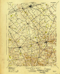 1943 Sabina1943 Print · USGSMid-century Clinton and Highland counties are shown here as a landscape of rail-connected towns and crossroads hamlets. Genealogists can trace family footprints through numerous rural schools like Slickaway Sch, Powderlick Sch, and the Centerville Lees Creek P O.
 - 1944 Map of Hillsboro
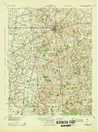 1944 Hillsboro1944 Print · USGSHighland County is documented here during the mid-forties, showing the vital rail junction at Hillsboro and a dense network of rural schools. Trace ancestral roots through localized landmarks like Brier College Sch, Mowrystown, and Millers Chapel Ch.
 - 1944 Map of Greenfield
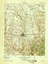 1944 Greenfield1944 Print · USGSMid-century Highland and Ross Counties center on the rail crossroads of Greenfield during the final years of the war. Genealogists can trace rural family life through dozens of named schoolhouses like Pikes Peak Sch and early settlements such as South Salem or Good Hope.
 - 1944 Map of Sardinia
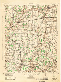 1944 Sardinia1944 Print · USGSSouthwestern Ohio during the Second World War was a landscape of dense rail networks and dozens of small school districts. Genealogists can trace family footprints through numerous rural landmarks like Richland Sch, Bardwell Corners, and the historic Ursuline Convent.
 - 1947 Map of Columbus, 1948 Print
 1947 Columbus1948 Print · USGSCentral Ohio in the late 1940s is captured in this survey, showing the post-war transition of its rail hubs and military airfield expansions. Genealogists and historians can trace the paths of the Ohio Canal, the Pennsylvania RR lines, and the Camp Sherman Military Reservation.
End of results
Showing maps 1-5 of 5
Top cities of Highland County
- Hillsboro historical maps
- Greenfield historical maps
- New Market historical maps
- Lynchburg historical maps
- Leesburg historical maps
- Marshall historical maps
See more
Frequently asked questions
- What are the different types of historical maps available for Highland County?
- What is the oldest map of Highland County?
- Where can I purchase historical maps of Highland County for my home or office?
- Where can I download high-res historical maps of Highland County?
- Are there historical topographic maps available for Highland County?
- Is there historical aerial imagery available for Highland County?
- Where are historical maps of Highland County sourced from?