1940s Maps of Comet, Wellston
Explore 2 historic maps of Comet from the 1940s. These maps offer a rare glimpse into what life looked like during the 1940s — showing old roads, neighborhoods, homes, and landmarks that have changed or disappeared over time.
Whether you're researching your family's past, planning a metal detecting trip, or studying how Comet's landscape evolved across the 1940s, these high-resolution maps are a powerful tool for exploring the history of this region.
- Focus on a specific era: All maps on this page are from the 1940s, giving you a focused view of this time period.
- See what’s changed: Compare century-old streets, trails, and buildings to today's modern landscape using overlays and satellite layers.
- Research with precision: Use these maps for genealogy, historical research, land use analysis, or educational projects.
- View, download, or print: Maps are fully viewable online in high resolution, and can be downloaded or printed for your own records.
Start exploring Comet's history through authentic maps from the 1940s. This is your window into the past.
Comet, Wellston maps
(2)- 1944 Map of Jackson
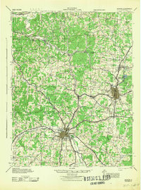 1944 Jackson1944 Print · USGSSouthern Ohio's industrial and rural heartland is detailed here during the mid-forties, centered on the coal and iron hubs of Jackson and Wellston. Genealogists can trace family roots through dozens of local landmarks like Ridgewood Cemetery and schools such as Oakland Sch.
 - 1947 Map of Columbus, 1948 Print
 1947 Columbus1948 Print · USGSCentral Ohio in the late 1940s is captured in this survey, showing the post-war transition of its rail hubs and military airfield expansions. Genealogists and historians can trace the paths of the Ohio Canal, the Pennsylvania RR lines, and the Camp Sherman Military Reservation.
End of results
Showing maps 1-2 of 2
Top cities near Comet
- Jackson historical maps
- Wellston historical maps
- McArthur historical maps
- Richland historical maps
- Oak Hill historical maps
- Hamden historical maps
See more
Frequently asked questions
- What are the different types of historical maps available for Comet?
- What is the oldest map of Comet?
- Where can I purchase historical maps of Comet for my home or office?
- Where can I download high-res historical maps of Comet?
- Are there historical topographic maps available for Comet?
- Is there historical aerial imagery available for Comet?
- Where are historical maps of Comet sourced from?