1910s Maps of Logan County, Ohio
Explore 12 historic maps of Logan County from the 1910s. These maps offer a rare glimpse into what life looked like during the 1910s — showing old roads, neighborhoods, homes, and landmarks that have changed or disappeared over time.
Whether you're researching your family's past, planning a metal detecting trip, or studying how Logan County's landscape evolved across the 1910s, these high-resolution maps are a powerful tool for exploring the history of this region.
- Focus on a specific era: All maps on this page are from the 1910s, giving you a focused view of this time period.
- See what’s changed: Compare century-old streets, trails, and buildings to today's modern landscape using overlays and satellite layers.
- Research with precision: Use these maps for genealogy, historical research, land use analysis, or educational projects.
- View, download, or print: Maps are fully viewable online in high resolution, and can be downloaded or printed for your own records.
Start exploring Logan County's history through authentic maps from the 1910s. This is your window into the past.
Logan County, OH maps
(12)- 1913 Map of Alger
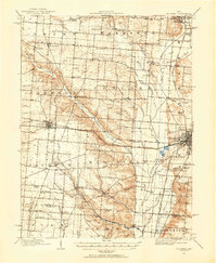
 1913 Alger1913 Print · USGSWestern Ohio's agricultural heartland is documented here just before the Great War, showing a landscape shaped by drainage ditches and rail lines. Locate family landmarks like the Bee Hive School, Mt Zion Church, and the vanished stops along the Chicago & Erie Railroad.2 unique versions available
 - 1913 Map of Bellefontaine
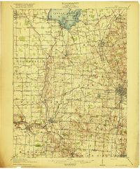
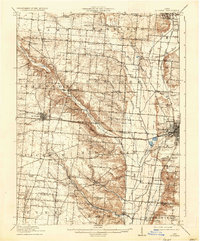
 1913 Bellefontaine1913 Print · USGSLogan County in the decade before the First World War shows a landscape connected by steam and electric rail. Genealogists can locate family landmarks from Santa Fe to Quincy, including the County Infirmary and old sites like Muchinippi Church.2 unique versions available
 - 1913 Map of Sidney, 1934 Print
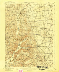
 1913 Sidney1934 Print · USGSShelby County at the height of the steam and electric rail era features a landscape defined by the Miami and Erie Canal and the historic Greenville Treaty Line. Genealogists and historians can trace dozens of rural schoolhouses, including Poplar Knob School and Walnut Grove School, alongside the early streetcar route of the Western Ohio RR.2 unique versions available
 - 1913 Map of East Liberty, 1961 Print
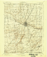
 1913 East Liberty1961 Print · USGSLogan and Union counties are shown here just before the First World War, when a dense network of country schools and steam railroads bound the countryside together. Genealogists can trace family footprints at Marl City, Indian Mound School, or the Greenville Treaty Line.
 - 1914 Map of St. Paris, 1954 Print
 1914 St. Paris1954 Print · USGSChampaign County at the height of the steam and electric rail era shows a landscape of thriving rural school districts and busy market towns. Trace the footprints of early education at Mt Jesse School or locate family roots near Millerstown and the County Infirmary.2 unique versions available
 - 1914 Map of Mechanicsburg, 1954 Print
 1914 Mechanicsburg1954 Print · USGSChampaign County at the start of the Great War was a thriving landscape of rail-connected villages and one-room schoolhouses. Genealogists can trace family footprints at Pretty Prairie School, the ancient Indian Mound, or along the busy tracks of the Erie RR in North Lewisburg.
 - 1915 Map of Alger
 1915 Alger1915 Print · USGSNorthwest Ohio's agricultural and rail heartland is captured here just before the First World War. Genealogists can locate family homesteads near dozens of early rural schoolhouses like Kingsley School and trace the paths of the ERIE RR and LAKEVIEW ELECTRIC ROAD.4 unique versions available
 - 1915 Map of Bellefontaine
 1915 Bellefontaine1915 Print · USGSLogan County at the start of the twentieth century shows a bustling landscape of rail hubs and lakeside settlements. Genealogists can trace family footprints at Richland New Richland PO or locate landmarks like the County Infirmary and Black Lake School.3 unique versions available
 - 1915 Map of East Liberty, 1941 Print
 1915 East Liberty1941 Print · USGSLogan County at the start of the twentieth century shows a landscape of established rail hubs and numerous rural school districts. Genealogists can trace family roots through landmarks like Zanesfield, Bethany School, and the historic Greenville Treaty Line.
 - 1915 Map of Kenton, 1942 Print
 1915 Kenton1942 Print · USGSHardin County at the dawn of the motorized age shows a landscape deeply connected by competing rail lines and rural school districts. Genealogists and historians can trace family roots at dozens of named schoolhouses like Henpeck and Brush College, or locate vanished stops along the Toledo and Ohio Central Railroad.
 - 1916 Map of Mechanicsburg, 1936 Print
 1916 Mechanicsburg1936 Print · USGSChampaign County at the height of the rail era shows a landscape where small villages and rural schoolhouses thrived alongside major transit corridors. Genealogists and historians can trace family locations near landmarks like Indian Mound, Catawba Station, and Five Points School.
 - 1916 Map of St. Paris, 1936 Print
 1916 St. Paris1936 Print · USGSChampaign and Clark counties are shown here just before the first World War, revealing a landscape of rural schoolhouses and bustling rail junctions. Researchers can locate family landmarks like the Speece School or trace the path of the Ohio Electric Ry through Tremont City.
End of results
Showing maps 1-12 of 12
Top cities of Logan County
- Bellefontaine historical maps
- De Graff historical maps
- West Mansfield historical maps
- Valley Hi historical maps
Frequently asked questions
- What are the different types of historical maps available for Logan County?
- What is the oldest map of Logan County?
- Where can I purchase historical maps of Logan County for my home or office?
- Where can I download high-res historical maps of Logan County?
- Are there historical topographic maps available for Logan County?
- Is there historical aerial imagery available for Logan County?
- Where are historical maps of Logan County sourced from?