
1913 Map of Alger
USGS Topo · Published 1913About this map
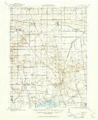
Indian Lake anchors the southern edge of this 1913 survey, featuring its intricate shoreline of islands like Walnut Ids and Roers I. This period in West-Central Ohio is defined by an extensive drainage network, where Cottonwood Ditch and Cooney Ditch cut across the flat terrain to manage the marshy lands for agriculture near Alger and McGuffey. The map reveals a densely settled rural landscape, punctuated by local landmarks like the Bee Hive School and the Mt Zion Church. Transport is dominated by the Chicago & Erie Railroad and the Toledo & Ohio Central Railway, which connected these farming communities to broader markets. The convergence of multiple county lines, including the Auglaize Co Hardin Co boundary, highlights the jurisdictional complexities of the era. Genealogists will find a wealth of specific local data in the numerous named schools like Mustard School and Rising Sun School scattered across the townships.
Find a feature on this map
94 named features on this map. Tap any name to fly to it.
Don’t see what you’re looking for? This feature index may not catch every label — zoom into the map to look around manually.
Map Details
Editions of this 1913 Alger Map
2 editions found
Other maps of this area

1905 · Arlington
USGS Topo · 1:62,500

1906 · Lima
USGS Topo · 1:62,500

1906 · Columbus Grove
USGS Topo · 1:62,500

1907 · Bluffton
USGS Topo · 1:62,500

1907 · Arlington
USGS Topo · 1:24,000

1908 · Columbus Grove
USGS Topo · 1:62,500

1913 · Bellefontaine
USGS Topo · 1:48,000

1913 · Sidney
USGS Topo · 1:62,500

1913 · East Liberty
USGS Topo · 1:62,500

1915 · Alger
USGS Topo · 1:62,500
Featured Places
- Alger, Marion Township
- Waynesfield, OH
- Belle Center, Richland Township
- Roundhead, Roundhead Township
- McGuffey, Marion Township