1913 Map of Alger
USGS Topo · Published 1961About this map
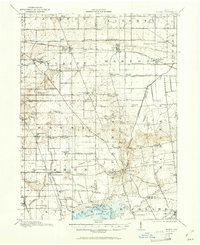
The Auglaize River and Scioto River headwaters define this landscape at the intersection of Hardin, Allen, Auglaize, and Logan counties. The drainage network is characterized by extensive reclamation efforts, visible in the straight channels of Cooney Ditch and Lord Ditch that cut through the mucklands near Alger and McGuffey. This infrastructure supported the local onion-growing industry, which relied on the Erie RR for transporting harvests from settlements like Harrod.
Find a feature on this map
96 named features on this map. Tap any name to fly to it.
Don’t see what you’re looking for? This feature index may not catch every label — zoom into the map to look around manually.
Map Details
Editions of this 1913 Alger Map
2 editions found
Other maps of this area

1905 · Arlington
USGS Topo · 1:62,500

1906 · Lima
USGS Topo · 1:62,500

1906 · Columbus Grove
USGS Topo · 1:62,500

1907 · Bluffton
USGS Topo · 1:62,500

1907 · Arlington
USGS Topo · 1:24,000

1908 · Columbus Grove
USGS Topo · 1:62,500

1913 · Alger
USGS Topo · 1:48,000

1913 · Bellefontaine
USGS Topo · 1:48,000

1913 · Sidney
USGS Topo · 1:62,500

1913 · East Liberty
USGS Topo · 1:62,500
Featured Places
- Alger, Marion Township
- Waynesfield, OH
- Belle Center, Richland Township
- Roundhead, Roundhead Township
- McGuffey, Marion Township