
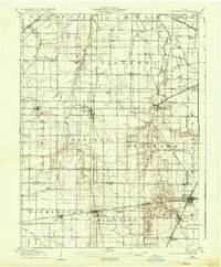
1907 Map of Arlington
USGS Topo · Published 1907About this map
Arlington and the surrounding townships of Eagle and Madison define this agricultural landscape at the turn of the twentieth century. The map reveals an intricate network of rural infrastructure, where family-named schools like Bishop School and Treece School served dispersed farming communities. Religious life is well-documented through landmarks such as Mt Moriah Church and Salem Church, providing valuable geographic anchors for genealogists.
Find a feature on this map
73 named features on this map. Tap any name to fly to it.
Don’t see what you’re looking for? This feature index may not catch every label — zoom into the map to look around manually.
Map Details
Editions of this 1907 Arlington Map
2 editions found
Other maps of this area

1901 · Fostoria
USGS Topo · 1:62,500

1903 · Fostoria
USGS Topo · 1:62,500

1903 · Findlay
USGS Topo · 1:62,500

1905 · Arlington
USGS Topo · 1:62,500

1907 · Bluffton
USGS Topo · 1:62,500

1907 · Upper Sandusky
USGS Topo · 1:62,500

1913 · Alger
USGS Topo · 1:48,000

1915 · Alger
USGS Topo · 1:62,500

1915 · Kenton
USGS Topo · 1:62,500

1915 · La Rue
USGS Topo · 1:62,500