1960s Maps of North Ridgeville, Ohio
Explore 6 historic maps of North Ridgeville from the 1960s. These maps offer a rare glimpse into what life looked like during the 1960s — showing old roads, neighborhoods, homes, and landmarks that have changed or disappeared over time.
Whether you're researching your family's past, planning a metal detecting trip, or studying how North Ridgeville's landscape evolved across the 1960s, these high-resolution maps are a powerful tool for exploring the history of this region.
- Focus on a specific era: All maps on this page are from the 1960s, giving you a focused view of this time period.
- See what’s changed: Compare century-old streets, trails, and buildings to today's modern landscape using overlays and satellite layers.
- Research with precision: Use these maps for genealogy, historical research, land use analysis, or educational projects.
- View, download, or print: Maps are fully viewable online in high resolution, and can be downloaded or printed for your own records.
Start exploring North Ridgeville's history through authentic maps from the 1960s. This is your window into the past.
North Ridgeville, OH maps
(6)- 1961 Map of Toledo
 1961 Toledo1961 Print · USGSThe western basin of Lake Erie and the industrial heart of Northern Ohio are captured here during the post-war era. Researchers can trace historical rail lines like the New York Central or locate landmarks like the Erie Ordnance Depot and Pelee Island.
 - 1962 Map of Cleveland
 1962 Cleveland1962 Print · USGSNortheast Ohio and the Pennsylvania borderlands appear here during the industrial peak of the early sixties. Genealogists and historians can trace the expansive rail lines of the Nickel Plate Road and the growth of suburbs from Parma to Lyndhurst.
 - 1963 Map of West View, 1964 Print
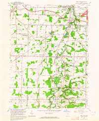 1963 West View1964 Print · USGSNortheast Ohio in the early sixties shows a landscape of transitioning farmland and growing townships at the Cuyahoga and Lorain county line. Researchers can trace the path of the New York Central railroad through Columbia Station or find family history at St Marys Cem and Myrtle Hill Cemetery.3 unique versions available
 - 1963 Map of Avon, 1964 Print
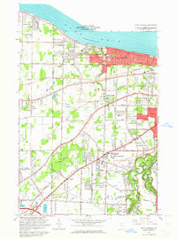
 1963 Avon1964 Print · USGSCoastal Lorain County is captured here during a decade of rapid suburban growth between the lakefront and the industrial centers. Researchers can trace the development of Sheffield Lake and Avon Lake, or locate family landmarks like St Teresa Cem and Weiss Field.3 unique versions available
 - 1963 Map of Grafton, 1964 Print
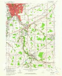 1963 Grafton1964 Print · USGSLorain County shows a blend of industrial growth and rural character in the early sixties as suburban neighborhoods began to expand. Genealogists can locate family sites near Ridgelawn Cem or trace the early development of Brentwood Lake and Eaton Estates.4 unique versions available
 - 1963 Map of North Olmsted, 1964 Print
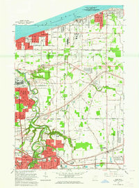
 1963 North Olmsted1964 Print · USGSCoastal life meets suburban expansion in the early sixties as communities like Bay Village and Westlake grow along the lakefront. Researchers can locate vanished landmarks like Bosworth Airport or trace family sites at Maple Ridge Cem and Evergreen Cem.4 unique versions available
End of results
Showing maps 1-6 of 6
Top cities near North Ridgeville
- Cleveland historical maps
- Lorain historical maps
- Elyria historical maps
- Lakewood historical maps
- Strongsville historical maps
- Brunswick historical maps
See more
Top neighborhoods of North Ridgeville
- Pine Ridge Trailer Park historical maps
- Fields historical maps
- Stone Creek historical maps
- Estates at Hampton Place historical maps
- West Point historical maps
- Hampton Place historical maps
See more
Frequently asked questions
- What are the different types of historical maps available for North Ridgeville?
- What is the oldest map of North Ridgeville?
- Where can I purchase historical maps of North Ridgeville for my home or office?
- Where can I download high-res historical maps of North Ridgeville?
- Are there historical topographic maps available for North Ridgeville?
- Is there historical aerial imagery available for North Ridgeville?
- Where are historical maps of North Ridgeville sourced from?