1920s Maps of Waldo Township, Ohio
Explore 2 historic maps of Waldo Township from the 1920s. These maps offer a rare glimpse into what life looked like during the 1920s — showing old roads, neighborhoods, homes, and landmarks that have changed or disappeared over time.
Whether you're researching your family's past, planning a metal detecting trip, or studying how Waldo Township's landscape evolved across the 1920s, these high-resolution maps are a powerful tool for exploring the history of this region.
- Focus on a specific era: All maps on this page are from the 1920s, giving you a focused view of this time period.
- See what’s changed: Compare century-old streets, trails, and buildings to today's modern landscape using overlays and satellite layers.
- Research with precision: Use these maps for genealogy, historical research, land use analysis, or educational projects.
- View, download, or print: Maps are fully viewable online in high resolution, and can be downloaded or printed for your own records.
Start exploring Waldo Township's history through authentic maps from the 1920s. This is your window into the past.
Waldo Township, OH maps
(2)- 1924 Map of Delaware, 1954 Print
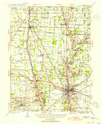 1924 Delaware1954 Print · USGSDelaware and its surrounding townships thrive in the mid-twenties as vital rail and river hubs. Researchers can trace the heritage of rural communities through dozens of local landmarks like Cherry Ridge School, Bethlehem Church, and Warrensburg.
 - 1925 Map of Delaware, 1940 Print
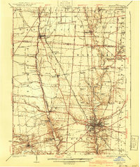 1925 Delaware1940 Print · USGSCentral Ohio in the mid-1920s is defined by its vibrant river valleys and shifting rail corridors. Genealogists can trace family roots through numerous country schools like Schoor School, rural parishes such as St James Church, and early settlements like Ostrander and Radnor.
End of results
Showing maps 1-2 of 2
Top cities near Waldo Township
- Delaware historical maps
- Marion historical maps
- Marysville historical maps
- Scioto historical maps
- Berkshire historical maps
- Mount Gilead historical maps
See more
Top neighborhoods of Waldo Township
Frequently asked questions
- What are the different types of historical maps available for Waldo Township?
- What is the oldest map of Waldo Township?
- Where can I purchase historical maps of Waldo Township for my home or office?
- Where can I download high-res historical maps of Waldo Township?
- Are there historical topographic maps available for Waldo Township?
- Is there historical aerial imagery available for Waldo Township?
- Where are historical maps of Waldo Township sourced from?