1960s Maps of Medina County, Ohio
Explore 23 historic maps of Medina County from the 1960s. These maps offer a rare glimpse into what life looked like during the 1960s — showing old roads, neighborhoods, homes, and landmarks that have changed or disappeared over time.
Whether you're researching your family's past, planning a metal detecting trip, or studying how Medina County's landscape evolved across the 1960s, these high-resolution maps are a powerful tool for exploring the history of this region.
- Focus on a specific era: All maps on this page are from the 1960s, giving you a focused view of this time period.
- See what’s changed: Compare century-old streets, trails, and buildings to today's modern landscape using overlays and satellite layers.
- Research with precision: Use these maps for genealogy, historical research, land use analysis, or educational projects.
- View, download, or print: Maps are fully viewable online in high resolution, and can be downloaded or printed for your own records.
Start exploring Medina County's history through authentic maps from the 1960s. This is your window into the past.
Medina County, OH maps
(23)- 1960 Map of Wellington, 1961 Print
 1960 Wellington1961 Print · USGSWellington stood as a vital rail hub in the early sixties, where the intersection of major lines defined the local economy. Researchers can trace the legacy of the Connecticut Western Reserve through landmarks like Greenwood Cem, Westwood Sch, and the grounds of Findley State Park.3 unique versions available
 - 1960 Map of Lagrange, 1963 Print
 1960 Lagrange1963 Print · USGSSouthern Lorain County was a landscape of rail crossings and oil derricks in the early sixties. Researchers can trace family history at Knowles Cem, locate the Preston Oil Field, and follow the New York Central through Lagrange.2 unique versions available
 - 1961 Map of Toledo
 1961 Toledo1961 Print · USGSThe western basin of Lake Erie and the industrial heart of Northern Ohio are captured here during the post-war era. Researchers can trace historical rail lines like the New York Central or locate landmarks like the Erie Ordnance Depot and Pelee Island.
 - 1961 Map of Seville, 1962 Print
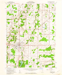
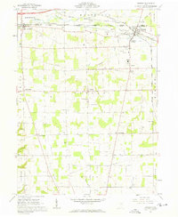
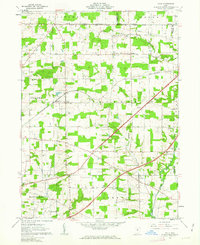
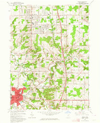
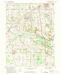
 1961 Seville1962 Print · USGSMedina County during the early sixties shows the arrival of the interstate system through a landscape of historic Western Reserve townships. Genealogists can locate family sites near Mound Hill Cem or trace rural life through the Old Mennonite Ch and River Styx corridor.5 unique versions available
 - 1961 Map of West Salem, 1962 Print
 1961 West Salem1962 Print · USGSWayne County farmland at the start of the sixties reveals a landscape shaped by historic land grants and early rail lines. Genealogists can trace family roots through numerous sites like Warners-Congress Cem, Fairhaven Ch, and the Burbank Station.2 unique versions available
 - 1961 Map of Creston, 1962 Print
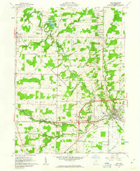
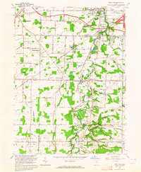
 1961 Creston1962 Print · USGSWayne and Medina counties are seen here in the early sixties, showing a landscape defined by busy rail junctions and small farming townships. Genealogists can locate Maple Mound Cem, the County Home for the Aged, and Canaan Center Cem.3 unique versions available
 - 1961 Map of Rittman, 1962 Print
 1961 Rittman1962 Print · USGSWayne County saw significant industrial salt extraction and rail development in the early sixties. Researchers can trace historic township boundaries and burial sites like Flickinger Cem or church locations such as Crown Hill Ch.3 unique versions available
 - 1961 Map of Leroy, 1963 Print
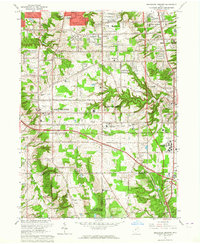
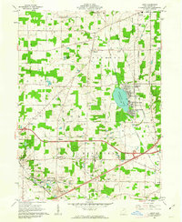 1961 Leroy1963 Print · USGSMedina County is captured in the early sixties during a period of transition between its agricultural roots and its role as a lakeside destination. Genealogists can trace family plots at Friendsville Cem or explore the rail-linked economies of Lodi and Seville.3 unique versions available
 - 1961 Map of Sullivan, 1963 Print
 1961 Sullivan1963 Print · USGSThe rural borderlands of Ashland, Medina, and Lorain counties are captured here in the early sixties as small farming hamlets like Sullivan and Homerville thrived. Genealogists can trace family landmarks such as Hubler Cem and Gould Cem or locate early school sites like the Black River High Sch.3 unique versions available
 - 1961 Map of Polk, 1963 Print
 1961 Polk1963 Print · USGSAshland County farmland is documented here in the early sixties, showing the transition from traditional rail commerce to modern highway travel. Genealogists can locate Albion Cem, St Johns Ch, and the rural settlement of Redhaw near the Muddy Fork.3 unique versions available
 - 1961 Map of Lodi, 1963 Print
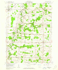
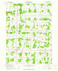
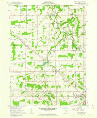
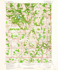
 1961 Lodi1963 Print · USGSMedina County is captured in the early sixties as a network of rail-side villages and rural crossroads communities. Trace the vanished footprints of old farmsteads through family burial grounds like Vanderhoef Cem and crossroads like Garden Isle or Esselburn.3 unique versions available
 - 1961 Map of Mallet Creek, 1963 Print
 1961 Mallet Creek1963 Print · USGSMedina County agriculture and rail industry meet in the early sixties at the junction of two major lines. Researchers can trace family roots through the York Cem and Branch Cem or locate the old Liverpool Sch and Buckeye High Sch.4 unique versions available
 - 1962 Map of Marion
 1962 Marion1962 Print · USGSCentral Ohio during the post-war era showcases a dense network of railroad towns and emerging interstate highways. Genealogists can trace family roots in smaller settlements like Houcktown and Marseilles or locate landmarks near Indian Lake.
 - 1962 Map of Canton
 1962 Canton1962 Print · USGSThe industrial heartland of Eastern Ohio and Western Pennsylvania thrives in the early sixties as steel mills and rail lines dominate the river valleys. Genealogists and historians can trace local landmarks like McKinley National Memorial, Malone College, and industrial sites such as Republic Steel Corp.2 unique versions available
 - 1962 Map of Cleveland
 1962 Cleveland1962 Print · USGSNortheast Ohio and the Pennsylvania borderlands appear here during the industrial peak of the early sixties. Genealogists and historians can trace the expansive rail lines of the Nickel Plate Road and the growth of suburbs from Parma to Lyndhurst.
 - 1963 Map of Berea, 1964 Print
 1963 Berea1964 Print · USGSBerea and its neighboring suburbs are captured here during a period of significant mid-century growth and residential expansion. Genealogists and local historians can trace family locations near Baldwin-Wallace College, find old burials at St Adalbert Cem, or locate landmarks like Strongsville Air Park.6 unique versions available
 - 1963 Map of Medina, 1964 Print
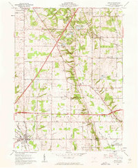
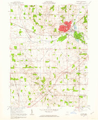
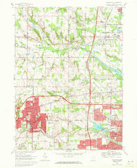
 1963 Medina1964 Print · USGSMedina and Brunswick show significant mid-century suburban growth during the early sixties as residential grids began to expand into the surrounding hills. Researchers can trace local genealogy and land use through sites like Township Cem, St Marks Ch, and the rural Sherman Corners.2 unique versions available
 - 1963 Map of West View, 1964 Print
 1963 West View1964 Print · USGSNortheast Ohio in the early sixties shows a landscape of transitioning farmland and growing townships at the Cuyahoga and Lorain county line. Researchers can trace the path of the New York Central railroad through Columbia Station or find family history at St Marys Cem and Myrtle Hill Cemetery.3 unique versions available
 - 1963 Map of Broadview Heights, 1964 Print
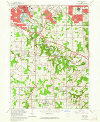
 1963 Broadview Heights1964 Print · USGSBroadview Heights and North Royalton are shown during a decade of rapid suburbanization and institutional growth. Local researchers can trace the development of the Ohio Turnpike alongside landmarks like the Veterans Administration Hospital and the Cleveland Ordnance Plant.5 unique versions available
 - 1963 Map of West Richfield, 1964 Print
 1963 West Richfield1964 Print · USGSThe Western Reserve landscape of Medina and Summit Counties was evolving quickly in the early sixties as suburban growth met rural industry. Genealogists and historians can trace family plots at Hinckley Ridge Cem or locate the site of the Cleveland Ordnance Plant.5 unique versions available
 - 1966 Map of Marion, 1968 Print
 1966 Marion1968 Print · USGSCentral Ohio in the mid-sixties is captured during a period of rapid highway expansion and industrial connectivity. Genealogists and historians can trace rail-and-river networks through towns like Marion, Urbana, and Mount Vernon, or locate landmarks such as Malabar Farm and Black Hand Rock.3 unique versions available
 - 1969 Map of Wadsworth, 1971 Print
 1969 Wadsworth1971 Print · USGSWestern Medina and Summit Counties are shown in the late sixties as suburban growth begins to merge old farming communities with industrial hubs. Researchers can trace the development of Wadsworth and Norton, locating vanished landmarks like the Drive-In Theater or long-standing sites like Sharon Center.2 unique versions available
 - 1969 Map of Doylestown, 1971 Print
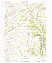
 1969 Doylestown1971 Print · USGSNortheast Ohio's industrial and agricultural character is captured here during the late sixties as suburban growth reached toward Doylestown. Researchers can trace rural lineages through sites like Maple Grove Cem or locate the Harvey Sch and the Penn Central rail lines.2 unique versions available
End of results
Showing maps 1-23 of 23
Top cities of Medina County
- Brunswick historical maps
- Medina historical maps
- Wadsworth historical maps
- Lodi historical maps
- Seville historical maps
- Westfield Center historical maps
See more
Frequently asked questions
- What are the different types of historical maps available for Medina County?
- What is the oldest map of Medina County?
- Where can I purchase historical maps of Medina County for my home or office?
- Where can I download high-res historical maps of Medina County?
- Are there historical topographic maps available for Medina County?
- Is there historical aerial imagery available for Medina County?
- Where are historical maps of Medina County sourced from?