1960s Maps of Guilford Township, Ohio
Explore 6 historic maps of Guilford Township from the 1960s. These maps offer a rare glimpse into what life looked like during the 1960s — showing old roads, neighborhoods, homes, and landmarks that have changed or disappeared over time.
Whether you're researching your family's past, planning a metal detecting trip, or studying how Guilford Township's landscape evolved across the 1960s, these high-resolution maps are a powerful tool for exploring the history of this region.
- Focus on a specific era: All maps on this page are from the 1960s, giving you a focused view of this time period.
- See what’s changed: Compare century-old streets, trails, and buildings to today's modern landscape using overlays and satellite layers.
- Research with precision: Use these maps for genealogy, historical research, land use analysis, or educational projects.
- View, download, or print: Maps are fully viewable online in high resolution, and can be downloaded or printed for your own records.
Start exploring Guilford Township's history through authentic maps from the 1960s. This is your window into the past.
Guilford Township, OH maps
(6)- 1961 Map of Seville, 1962 Print
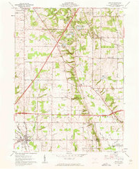 1961 Seville1962 Print · USGSMedina County during the early sixties shows the arrival of the interstate system through a landscape of historic Western Reserve townships. Genealogists can locate family sites near Mound Hill Cem or trace rural life through the Old Mennonite Ch and River Styx corridor.5 unique versions available
 - 1961 Map of Creston, 1962 Print
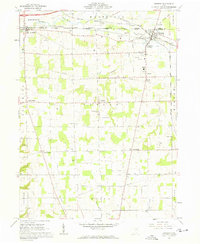 1961 Creston1962 Print · USGSWayne and Medina counties are seen here in the early sixties, showing a landscape defined by busy rail junctions and small farming townships. Genealogists can locate Maple Mound Cem, the County Home for the Aged, and Canaan Center Cem.3 unique versions available
 - 1961 Map of Rittman, 1962 Print
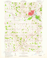 1961 Rittman1962 Print · USGSWayne County saw significant industrial salt extraction and rail development in the early sixties. Researchers can trace historic township boundaries and burial sites like Flickinger Cem or church locations such as Crown Hill Ch.3 unique versions available
 - 1961 Map of Leroy, 1963 Print
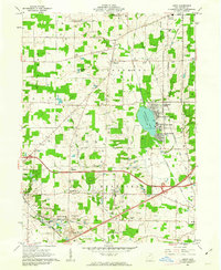 1961 Leroy1963 Print · USGSMedina County is captured in the early sixties during a period of transition between its agricultural roots and its role as a lakeside destination. Genealogists can trace family plots at Friendsville Cem or explore the rail-linked economies of Lodi and Seville.3 unique versions available
 - 1962 Map of Canton
 1962 Canton1962 Print · USGSThe industrial heartland of Eastern Ohio and Western Pennsylvania thrives in the early sixties as steel mills and rail lines dominate the river valleys. Genealogists and historians can trace local landmarks like McKinley National Memorial, Malone College, and industrial sites such as Republic Steel Corp.2 unique versions available
 - 1962 Map of Cleveland
 1962 Cleveland1962 Print · USGSNortheast Ohio and the Pennsylvania borderlands appear here during the industrial peak of the early sixties. Genealogists and historians can trace the expansive rail lines of the Nickel Plate Road and the growth of suburbs from Parma to Lyndhurst.
End of results
Showing maps 1-6 of 6
Top cities near Guilford Township
- Akron historical maps
- Brunswick historical maps
- Massillon historical maps
- Wooster historical maps
- Medina historical maps
- Barberton historical maps
See more
Top neighborhoods of Guilford Township
Frequently asked questions
- What are the different types of historical maps available for Guilford Township?
- What is the oldest map of Guilford Township?
- Where can I purchase historical maps of Guilford Township for my home or office?
- Where can I download high-res historical maps of Guilford Township?
- Are there historical topographic maps available for Guilford Township?
- Is there historical aerial imagery available for Guilford Township?
- Where are historical maps of Guilford Township sourced from?