1990s Maps of Hinckley Township, Ohio
Explore 5 historic maps of Hinckley Township from the 1990s. These maps offer a rare glimpse into what life looked like during the 1990s — showing old roads, neighborhoods, homes, and landmarks that have changed or disappeared over time.
Whether you're researching your family's past, planning a metal detecting trip, or studying how Hinckley Township's landscape evolved across the 1990s, these high-resolution maps are a powerful tool for exploring the history of this region.
- Focus on a specific era: All maps on this page are from the 1990s, giving you a focused view of this time period.
- See what’s changed: Compare century-old streets, trails, and buildings to today's modern landscape using overlays and satellite layers.
- Research with precision: Use these maps for genealogy, historical research, land use analysis, or educational projects.
- View, download, or print: Maps are fully viewable online in high resolution, and can be downloaded or printed for your own records.
Start exploring Hinckley Township's history through authentic maps from the 1990s. This is your window into the past.
Hinckley Township, OH maps
(5)- 1994 Map of Cleveland South
 1994 Cleveland South1994 Print · USGSThe metropolitan corridor between Akron and Cleveland is shown here in the mid-nineties during a period of significant suburban growth. Researchers can trace the path of the Ohio Turnpike or explore expansive recreation lands like West Branch State Park.
 - 1994 Map of Broadview Heights, 1997 Print
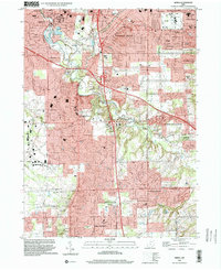
 1994 Broadview Heights1997 Print · USGSSuburban development meets the protected valley south of Cleveland in the mid-1990s. Genealogists and historians can trace institutional landmarks like St Peter and Paul Cemetery and the Veterans Administration Hospital.
 - 1994 Map of West Richfield, 1997 Print
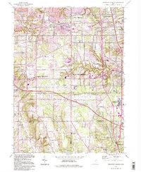
 1994 West Richfield1997 Print · USGSMedina and Summit counties are captured during a period of suburban expansion and parkland preservation in the mid-1990s. Researchers can locate long-standing landmarks like Beach Cem, the Township School, and the grounds of the Hinckley Reservation.
 - 1994 Map of Medina, 1997 Print
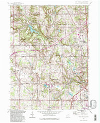
 1994 Medina1997 Print · USGSThe northern reaches of Medina County come into focus during the 1990s as suburban expansion meets traditional crossroads. Genealogists and local researchers can trace family plots at Townhall Cem or explore the development near Weymouth and Lake Brunswick.
 - 1994 Map of Berea, 2000 Print
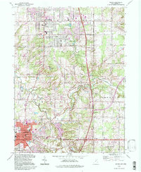
 1994 Berea2000 Print · USGSCuyahoga and Medina Counties are seen here during a period of significant suburban expansion in the 1990s. Genealogists and local historians can trace the development of Berea and Strongsville, locating landmarks like Woodvale Cem, Baldwin-Wallace College, and the old CONRAIL lines.
End of results
Showing maps 1-5 of 5
Top cities near Hinckley Township
- Cleveland historical maps
- Akron historical maps
- Parma historical maps
- Cuyahoga Falls historical maps
- Lakewood historical maps
- Strongsville historical maps
See more
Top neighborhoods of Hinckley Township
Frequently asked questions
- What are the different types of historical maps available for Hinckley Township?
- What is the oldest map of Hinckley Township?
- Where can I purchase historical maps of Hinckley Township for my home or office?
- Where can I download high-res historical maps of Hinckley Township?
- Are there historical topographic maps available for Hinckley Township?
- Is there historical aerial imagery available for Hinckley Township?
- Where are historical maps of Hinckley Township sourced from?