1960s Maps of Syracuse, Ohio
Explore 4 historic maps of Syracuse from the 1960s. These maps offer a rare glimpse into what life looked like during the 1960s — showing old roads, neighborhoods, homes, and landmarks that have changed or disappeared over time.
Whether you're researching your family's past, planning a metal detecting trip, or studying how Syracuse's landscape evolved across the 1960s, these high-resolution maps are a powerful tool for exploring the history of this region.
- Focus on a specific era: All maps on this page are from the 1960s, giving you a focused view of this time period.
- See what’s changed: Compare century-old streets, trails, and buildings to today's modern landscape using overlays and satellite layers.
- Research with precision: Use these maps for genealogy, historical research, land use analysis, or educational projects.
- View, download, or print: Maps are fully viewable online in high resolution, and can be downloaded or printed for your own records.
Start exploring Syracuse's history through authentic maps from the 1960s. This is your window into the past.
Syracuse, OH maps
(4)- 1960 Map of Chester, 1962 Print
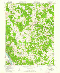 1960 Chester1962 Print · USGSMeigs County and the Ohio River riverfront thrived in the early sixties, balancing heavy industry with rural ridge-top life. Researchers can trace ancestral lands through family sites like Nease Settlement, the Welsh Town Cem, and the Chester Hill Country Club.4 unique versions available
 - 1961 Map of Clarksburg
 1961 Clarksburg1961 Print · USGSThe mid-century industrial and river landscapes of West Virginia and Ohio are detailed here, centered on the Ohio River. Researchers can trace the Baltimore and Ohio rail lines connecting towns like Parkersburg, Clarksburg, and Monongah.
 - 1961 Map of Charleston
 1961 Charleston1961 Print · USGSWest Virginia's capital region and the highlands to the east are shown in detail during the early sixties. Genealogists and historians can trace rail networks like the Baltimore and Ohio RR and find early state parks such as Watoga State Park.
 - 1968 Map of New Haven, 1969 Print
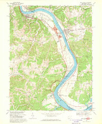 1968 New Haven1969 Print · USGSThe Ohio River corridor comes alive in the late sixties as industrial hubs like New Haven and Graham Station sit alongside ancient landmarks. Genealogists and historians can trace family burial sites at Evergreen Cem or locate the Indian Mound and the Racine Locks and Dam.3 unique versions available
End of results
Showing maps 1-4 of 4
Top cities near Syracuse
- Point Pleasant historical maps
- Gallipolis historical maps
- Ravenswood historical maps
- Middleport historical maps
- Addison historical maps
- Chester historical maps
See more
Frequently asked questions
- What are the different types of historical maps available for Syracuse?
- What is the oldest map of Syracuse?
- Where can I purchase historical maps of Syracuse for my home or office?
- Where can I download high-res historical maps of Syracuse?
- Are there historical topographic maps available for Syracuse?
- Is there historical aerial imagery available for Syracuse?
- Where are historical maps of Syracuse sourced from?