1950s Maps of Miami County, Ohio
Explore 7 historic maps of Miami County from the 1950s. These maps offer a rare glimpse into what life looked like during the 1950s — showing old roads, neighborhoods, homes, and landmarks that have changed or disappeared over time.
Whether you're researching your family's past, planning a metal detecting trip, or studying how Miami County's landscape evolved across the 1950s, these high-resolution maps are a powerful tool for exploring the history of this region.
- Focus on a specific era: All maps on this page are from the 1950s, giving you a focused view of this time period.
- See what’s changed: Compare century-old streets, trails, and buildings to today's modern landscape using overlays and satellite layers.
- Research with precision: Use these maps for genealogy, historical research, land use analysis, or educational projects.
- View, download, or print: Maps are fully viewable online in high resolution, and can be downloaded or printed for your own records.
Start exploring Miami County's history through authentic maps from the 1950s. This is your window into the past.
Miami County, OH maps
(7)- 1953 Map of Cincinnati, 1965 Print
 1953 Cincinnati1965 Print · USGSThe Ohio River valley and the industrial heartland of Indiana and Ohio are captured here during the mid-century peak of rail and river commerce. Genealogists and historians can trace connections between Cincinnati and outlying military sites like Camp Atterbury and Bakalar AFB.3 unique versions available
 - 1953 Map of Muncie, 1966 Print
 1953 Muncie1966 Print · USGSIndiana and Ohio borderlands thrive in the early fifties, showing a landscape defined by manufacturing cities and an intensive railroad network. Genealogists can trace family roots across the Indiana-Ohio line through Muncie, Celina, and Portland via the Pennsylvania railroad.5 unique versions available
 - 1955 Map of West Milton, 1956 Print
 1955 West Milton1956 Print · USGSMiami and Montgomery counties in the mid-fifties reveal a landscape of river-bend settlements and rural townships. Trace family roots at Wheelock Cem, locate the old Township Sch, or find the Drive-in Theater near the Stillwater River.5 unique versions available
 - 1955 Map of Tipp City, 1956 Print
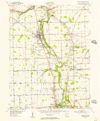
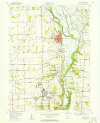 1955 Tipp City1956 Print · USGSMiami County and Montgomery County meet along the river in the mid-fifties as the region transitions from its canal-era roots to a modern aviation hub. Genealogists can trace family landmarks like English Cemetery or Middle District Church while following the historic Miami and Erie Canal.
 - 1955 Map of New Carlisle, 1956 Print
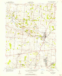 1955 New Carlisle1956 Print · USGSIn the mid-1950s, the rural borderlands between Miami and Clark Counties centered on the growing town of New Carlisle. Genealogists and researchers can trace family landmarks like Walnut Grove Cem, McKendree Ch, and the many schools and cemeteries dotting the Honey Creek valley.4 unique versions available
 - 1956 Map of Muncie
 1956 Muncie1956 Print · USGSEastern Indiana and western Ohio are shown at a peak of rail-driven industry in the mid-fifties. Genealogists and rail historians can trace the paths of the Pennsylvania RR through Muncie or locate landmarks like Lake Saint Marys (Grand Lake Reservoir) and Frances Slocum State Forest.
 - 1957 Map of Cincinnati
 1957 Cincinnati1957 Print · USGSThe Ohio River valley and its surrounding highlands thrived during the mid-fifties industrial peak, centered on the bustling Cincinnati and Dayton metropolitan hubs. Researchers can trace the extensive rail networks and military sites like Wright-Patterson AFB and Camp Atterbury.
End of results
Showing maps 1-7 of 7
Top cities of Miami County
- Troy historical maps
- Piqua historical maps
- Tipp City historical maps
- West Milton historical maps
- Covington historical maps
- Staunton historical maps
See more
Frequently asked questions
- What are the different types of historical maps available for Miami County?
- What is the oldest map of Miami County?
- Where can I purchase historical maps of Miami County for my home or office?
- Where can I download high-res historical maps of Miami County?
- Are there historical topographic maps available for Miami County?
- Is there historical aerial imagery available for Miami County?
- Where are historical maps of Miami County sourced from?