1900s (20th Century) Maps of Miami County, Ohio
Explore 26 historic maps of Miami County from the 1900s (20th Century). These maps offer a rare glimpse into what life looked like during the 1900s — showing old roads, neighborhoods, homes, and landmarks that have changed or disappeared over time.
Whether you're researching your family's past, planning a metal detecting trip, or studying how Miami County's landscape evolved across the 1900s, these high-resolution maps are a powerful tool for exploring the history of this region.
- Focus on a specific era: All maps on this page are from the 1900s, giving you a focused view of this time period.
- See what’s changed: Compare century-old streets, trails, and buildings to today's modern landscape using overlays and satellite layers.
- Research with precision: Use these maps for genealogy, historical research, land use analysis, or educational projects.
- View, download, or print: Maps are fully viewable online in high resolution, and can be downloaded or printed for your own records.
Start exploring Miami County's history through authentic maps from the 1900s. This is your window into the past.
Miami County, OH maps
(26)- 1904 Map of Dayton, 1956 Print
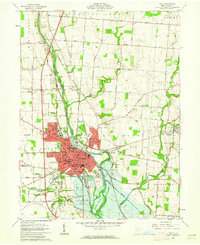
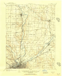 1904 Dayton1956 Print · USGSThe Miami Valley at the dawn of the 1900s shows a landscape transformed by the Miami and Erie Canal and a dense network of interurban electric railways. Researchers can trace historic river communities like Osborn and Tipp City or follow the early path of the National Road.
 - 1905 Map of Brookville, 1953 Print
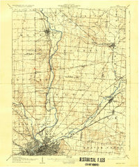
 1905 Brookville1953 Print · USGSWestern Montgomery County in the early 1900s shows a landscape of rail-connected farming towns and early river management. Trace the path of the historic National Road through Arlington or locate family sites near Shiloh Church and Harshbarger Schoolhouse.
 - 1906 Map of Dayton, 1935 Print
 1906 Dayton1935 Print · USGSThe Dayton region in the early twentieth century shows a landscape transitioning from the canal era to the age of electric interurbans and railroads. Trace the original sites of Osborn and Fairfield or locate the path of the Miami and Erie Canal.2 unique versions available
 - 1911 Map of Covington, 1946 Print
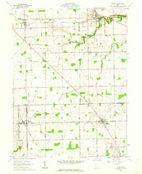
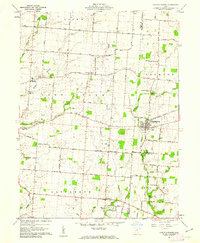
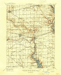 1911 Covington1946 Print · USGSWestern Ohio’s agricultural heartland is mapped here as a web of turnpikes and railroads connects thriving towns. Trace old family sites near Bradford, Gettysburg, and uniquely named rural landmarks like Lickskillet School or Cassels Corners.
 - 1914 Map of Troy, 1931 Print
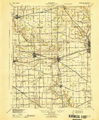
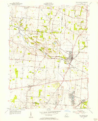
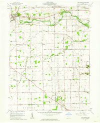
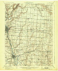 1914 Troy1931 Print · USGSMiami County at the height of the interurban era shows a landscape defined by the Miami River and competing rail lines. Genealogists can locate family landmarks like the County Infirmary or schools such as Sheepskin School and Frogpond School.2 unique versions available
 - 1944 Map of Covington
 1944 Covington1944 Print · USGSWestern Ohio at the end of the Second World War remains a landscape of thriving rural rail towns and country schoolhouses. Researchers can trace the Stillwater River to find Greenville Falls, the Forest Hill Cem, and local landmarks like Tadpole Sch and Ludlow Falls.
 - 1944 Map of Troy
 1944 Troy1944 Print · USGSMiami County during the mid-forties reveals a landscape of industrial river towns and an incredibly dense network of rural schools. Researchers can trace the path of the Miami and Erie Canal and locate family-named landmarks like Rhodhammel Sch and Staunton.
 - 1953 Map of Cincinnati, 1965 Print
 1953 Cincinnati1965 Print · USGSThe Ohio River valley and the industrial heartland of Indiana and Ohio are captured here during the mid-century peak of rail and river commerce. Genealogists and historians can trace connections between Cincinnati and outlying military sites like Camp Atterbury and Bakalar AFB.3 unique versions available
 - 1953 Map of Muncie, 1966 Print
 1953 Muncie1966 Print · USGSIndiana and Ohio borderlands thrive in the early fifties, showing a landscape defined by manufacturing cities and an intensive railroad network. Genealogists can trace family roots across the Indiana-Ohio line through Muncie, Celina, and Portland via the Pennsylvania railroad.5 unique versions available
 - 1955 Map of West Milton, 1956 Print
 1955 West Milton1956 Print · USGSMiami and Montgomery counties in the mid-fifties reveal a landscape of river-bend settlements and rural townships. Trace family roots at Wheelock Cem, locate the old Township Sch, or find the Drive-in Theater near the Stillwater River.5 unique versions available
 - 1955 Map of Tipp City, 1956 Print
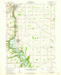
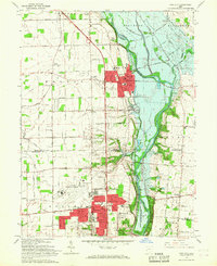
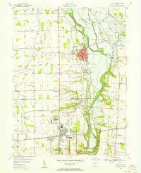 1955 Tipp City1956 Print · USGSMiami County and Montgomery County meet along the river in the mid-fifties as the region transitions from its canal-era roots to a modern aviation hub. Genealogists can trace family landmarks like English Cemetery or Middle District Church while following the historic Miami and Erie Canal.
 - 1955 Map of New Carlisle, 1956 Print
 1955 New Carlisle1956 Print · USGSIn the mid-1950s, the rural borderlands between Miami and Clark Counties centered on the growing town of New Carlisle. Genealogists and researchers can trace family landmarks like Walnut Grove Cem, McKendree Ch, and the many schools and cemeteries dotting the Honey Creek valley.4 unique versions available
 - 1956 Map of Muncie
 1956 Muncie1956 Print · USGSEastern Indiana and western Ohio are shown at a peak of rail-driven industry in the mid-fifties. Genealogists and rail historians can trace the paths of the Pennsylvania RR through Muncie or locate landmarks like Lake Saint Marys (Grand Lake Reservoir) and Frances Slocum State Forest.
 - 1957 Map of Cincinnati
 1957 Cincinnati1957 Print · USGSThe Ohio River valley and its surrounding highlands thrived during the mid-fifties industrial peak, centered on the bustling Cincinnati and Dayton metropolitan hubs. Researchers can trace the extensive rail networks and military sites like Wright-Patterson AFB and Camp Atterbury.
 - 1961 Map of Laura, 1962 Print
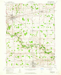
 1961 Laura1962 Print · USGSWestern Ohio farm country and quiet crossroads villages thrive in the early sixties across this multi-county border. Genealogists can trace family names through Mote Cem and Swank Cem or locate old homesteads near Potsdam and Pittsburg.2 unique versions available
 - 1961 Map of Piqua West, 1962 Print
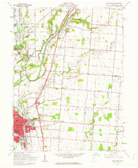
 1961 Piqua West1962 Print · USGSWestern Miami County is captured here in the early sixties as the suburbs of Piqua expanded toward Newberry and Washington townships. Researchers can trace family history through sites like Forest Hill Cemetery, St Teresas Ch, and the rural Mount Jefferson crossroads.4 unique versions available
 - 1961 Map of Piqua East, 1962 Print
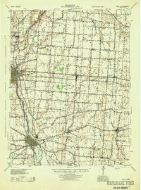
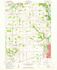
 1961 Piqua East1962 Print · USGSMiami County during the early sixties shows the industrial hub of Piqua at a crossroads of rail and river commerce. Genealogists and local historians can trace the Miami and Erie Canal path or locate family sites at Garby Cem No 1 and Kirkwood.4 unique versions available
 - 1961 Map of Troy, 1962 Print
 1961 Troy1962 Print · USGSThe Miami River valley shows significant post-war growth around Troy in the early sixties. Genealogists can trace family landmarks at Riverside Cemetery and Knoop Cem or the rural Staunton Sch.5 unique versions available
 - 1961 Map of Pleasant Hill, 1962 Print
 1961 Pleasant Hill1962 Print · USGSMiami County at the start of the sixties reveals a landscape of thriving river towns and established family farms. Researchers can trace the ancestral connections between Pleasant Hill and Covington or locate specific sites like the Concord Township Sch and Old Union Cem.2 unique versions available
 - 1961 Map of Versailles, 1962 Print
 1961 Versailles1962 Print · USGSThe rural crossroads of Darke, Shelby, and Miami counties come into focus during the early sixties, centered on the rail hubs of Versailles and Bradford. Researchers can trace old family sites and rural landmarks like St Peters Ch, St Valberts Cem, and the Childrens Home.2 unique versions available
 - 1961 Map of Fletcher, 1962 Print
 1961 Fletcher1962 Print · USGSIn the early 1960s, these western Ohio farm communities remained centered on their rail stops and rural churches. Genealogists can trace family footprints near Fletcher, Conover, and Plattsville, or find local burial grounds like Pioneer Cem and Sturm Cem.3 unique versions available
 - 1961 Map of Gettysburg, 1962 Print
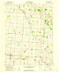
 1961 Gettysburg1962 Print · USGSGettysburg and its neighboring townships in Darke and Miami counties are captured in the early 1960s, showing a landscape of productive farmland and small rural crossroads. Genealogists and local historians can trace family roots through sites like Newcomers Cem, Pattytown, and the German Ch.2 unique versions available
 - 1961 Map of Christiansburg, 1962 Print
 1961 Christiansburg1962 Print · USGSChristiansburg and the surrounding Miami County farmland are captured here in the early sixties, showing a landscape of family farms and country schools. Genealogists can trace deep local roots through numerous small burial sites like Sodom Cem and Huddleston-Sills Cem.3 unique versions available
 - 1965 Map of Tipp City, 1967 Print
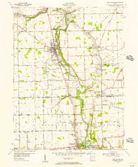
 1965 Tipp City1967 Print · USGSMiami County's river valley transition is captured here in the mid-sixties as Vandalia and Tipp City expand toward the Dayton Municipal Airport. Researchers can trace old family landmarks and rural hubs like Pearson Cem, Ginghamsburg, and the Middle District Sch.4 unique versions available
 - 1986 Map of Piqua
 1986 Piqua1986 Print · USGSThe western Ohio and eastern Indiana borderlands appear here in the mid-1980s, showcasing a landscape of river-valley industry and fertile plains. Researchers can trace historic rail lines like Conrail and Norfolk and Western through towns like Greenville and Winchester.3 unique versions available
Showing maps 1-25 of 26
Top cities of Miami County
- Troy historical maps
- Piqua historical maps
- Tipp City historical maps
- West Milton historical maps
- Covington historical maps
- Staunton historical maps
See more
Frequently asked questions
- What are the different types of historical maps available for Miami County?
- What is the oldest map of Miami County?
- Where can I purchase historical maps of Miami County for my home or office?
- Where can I download high-res historical maps of Miami County?
- Are there historical topographic maps available for Miami County?
- Is there historical aerial imagery available for Miami County?
- Where are historical maps of Miami County sourced from?