2000-2009 Maps of Lebanon, Bethel Township
Explore 1 historic maps of Lebanon from 2000-2009. These maps offer a rare glimpse into what life looked like during the 2000s — showing old roads, neighborhoods, homes, and landmarks that have changed or disappeared over time.
Whether you're researching your family's past, planning a metal detecting trip, or studying how Lebanon's landscape evolved across the 2000s, these high-resolution maps are a powerful tool for exploring the history of this region.
- Focus on a specific era: All maps on this page are from the 2000s, giving you a focused view of this time period.
- See what’s changed: Compare century-old streets, trails, and buildings to today's modern landscape using overlays and satellite layers.
- Research with precision: Use these maps for genealogy, historical research, land use analysis, or educational projects.
- View, download, or print: Maps are fully viewable online in high resolution, and can be downloaded or printed for your own records.
Start exploring Lebanon's history through authentic maps from the 2000s. This is your window into the past.
Lebanon, Bethel Township maps
(1)- 2002 Map of Dalzell, 2006 Print
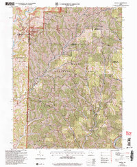 2002 Dalzell2006 Print · USGSSoutheast Ohio’s rural landscape is captured here just after the turn of the millennium, showing a region defined by forest and small-scale industry. Genealogists and local historians can trace family ties at Zion Ch (Cem) or find the historic Hune Covered Bridge.
End of results
Showing maps 1-1 of 1
Top cities near Lebanon
- Marietta historical maps
- Williamstown historical maps
- Woodsfield historical maps
- Newport historical maps
- Caldwell historical maps
- Grandview historical maps
See more
Frequently asked questions
- What are the different types of historical maps available for Lebanon?
- What is the oldest map of Lebanon?
- Where can I purchase historical maps of Lebanon for my home or office?
- Where can I download high-res historical maps of Lebanon?
- Are there historical topographic maps available for Lebanon?
- Is there historical aerial imagery available for Lebanon?
- Where are historical maps of Lebanon sourced from?