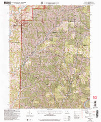
2002 Map of Dalzell
USGS Topo · Published 2006About this map
Wayne National Forest dominates this section of southeast Ohio, where the winding drainage of Pawpaw Creek and Fifteenmile Creek defines the landscape. The map reveals a deeply etched topography of ridges like Sowery Ridge and numerous small hollows that once supported a network of dispersed communities and hilltop cemeteries. Genealogical interest is concentrated in sites such as Zion Ch (Cem) and Master Ch (Cem), which reflect the 19th-century settlement patterns of Washington and Noble counties. Significant landmarks include the Hune Covered Bridge and its adjacent Hune Bridge Canoe Access on the Little Indian Run. The map also illustrates the region's industrial footprint, showing scattered Gas Well sites and Strip Mines along the northern reaches of Duck Creek, indicating a land where timber, energy extraction, and small-scale farming have long coexisted.
Find a feature on this map
47 named features on this map. Tap any name to fly to it.
Don’t see what you’re looking for? This feature index may not catch every label — zoom into the map to look around manually.
Map Details
Editions of this 2002 Dalzell Map
This is the sole edition of this map. No revisions or reprints were ever made.
Other maps of this area

1903 · Macksburg
USGS Topo · 1:62,500

1904 · Marietta
USGS Topo · 1:62,500

1905 · New Matamoras
USGS Topo · 1:62,500

1905 · Macksburg
USGS Topo · 1:62,500

1906 · Saint Marys
USGS Topo · 1:62,500

1924 · St Marys
USGS Topo · 1:62,500

1924 · New Matamoras
USGS Topo · 1:62,500

1924 · Marietta
USGS Topo · 1:62,500

1926 · New Matamoras
USGS Topo · 1:62,500

1927 · Marietta
USGS Topo · 1:62,500