1960s Maps of Kettering, Ohio
Explore 2 historic maps of Kettering from the 1960s. These maps offer a rare glimpse into what life looked like during the 1960s — showing old roads, neighborhoods, homes, and landmarks that have changed or disappeared over time.
Whether you're researching your family's past, planning a metal detecting trip, or studying how Kettering's landscape evolved across the 1960s, these high-resolution maps are a powerful tool for exploring the history of this region.
- Focus on a specific era: All maps on this page are from the 1960s, giving you a focused view of this time period.
- See what’s changed: Compare century-old streets, trails, and buildings to today's modern landscape using overlays and satellite layers.
- Research with precision: Use these maps for genealogy, historical research, land use analysis, or educational projects.
- View, download, or print: Maps are fully viewable online in high resolution, and can be downloaded or printed for your own records.
Start exploring Kettering's history through authentic maps from the 1960s. This is your window into the past.
Kettering, OH maps
(2)- 1965 Map of Bellbrook, 1967 Print
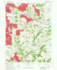 1965 Bellbrook1967 Print · USGSGreene and Montgomery Counties are captured during a period of suburban transition in the mid-1960s. Researchers can locate family landmarks like the Pioneer Cem, the historic Covered Bridge, and old schoolhouses including Bell Sch.5 unique versions available
 - 1966 Map of Dayton South, 1968 Print
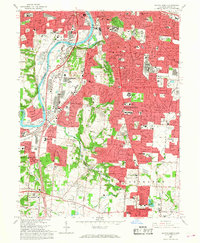 1966 Dayton South1968 Print · USGSThe southern suburbs of Montgomery County were rapidly expanding in the mid-sixties as Dayton reached into the surrounding hills. Researchers can trace institutional history and family locations at the Dayton State Hospital, Calvary Cemetery, and the Gentile AF Depot.5 unique versions available
End of results
Showing maps 1-2 of 2
Top cities near Kettering
- Dayton historical maps
- Middletown historical maps
- Beavercreek historical maps
- Huber Heights historical maps
- Fairborn historical maps
- Trotwood historical maps
See more
Top neighborhoods of Kettering
- Southeast Dayton historical maps
- Southern Hills historical maps
- Pasadena historical maps
- Berkley Heights historical maps
- Carmonte historical maps
- Greenmont historical maps
See more
Frequently asked questions
- What are the different types of historical maps available for Kettering?
- What is the oldest map of Kettering?
- Where can I purchase historical maps of Kettering for my home or office?
- Where can I download high-res historical maps of Kettering?
- Are there historical topographic maps available for Kettering?
- Is there historical aerial imagery available for Kettering?
- Where are historical maps of Kettering sourced from?