Old Maps of Morrow County, Ohio for Genealogy
Trace your family roots with 110 historic maps of Morrow County. These high-res maps reveal old neighborhoods, homesites, landmarks, and streets — helping you uncover where your ancestors lived and how the area evolved over time.
- Explore historic neighborhoods: Identify where your relatives may have lived in the 1800s or 1900s.
- Compare maps over time: Trace the changes in streets, buildings, and landmarks for multi-generational research.
- Perfect for genealogy & ancestry research: Used by family historians and researchers to map out lineage and migration.
These maps are an incredible resource for exploring your personal connection to Morrow County's past.
Morrow County, OH maps
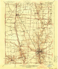
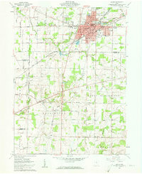
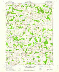
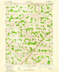
(110)- 1913 Map of Mount Gilead, 1960 Print
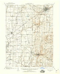 1913 Mount Gilead1960 Print · USGSNorth Central Ohio during the early rail era reveals a landscape densely packed with small-town life and rural school districts. Genealogists can trace family roots through dozens of local landmarks, from Hog Swamp School to the bustling rail junctions at Martel and Galion.
 - 1915 Map of Shauck, 1946 Print
 1915 Shauck1946 Print · USGSRichland County and its neighbors are captured here just before the First World War, showing a landscape of established rail hubs and rural school districts. Genealogists can locate family homesteads near Johnsville Shauck PO, Steam Corners, or Bellville.
 - 1915 Map of Marengo, 1946 Print
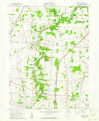
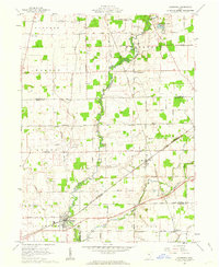
 1915 Marengo1946 Print · USGSMorrow and Delaware counties are shown in detail during the heyday of the steam railroad and the one-room schoolhouse. Genealogists and historians can locate vanished local landmarks like Swamp Angel School, the County Infirmary, and the Treaty Line.
 - 1915 Map of Fredericktown, 1950 Print
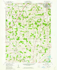
 1915 Fredericktown1950 Print · USGSKnox and Morrow Counties are shown here during the height of the steam-rail era. Genealogists can locate dozens of country schoolhouses like Salem and Updike, alongside family landmarks such as Braddock Mound and the County Infirmary.
 - 1916 Map of Mount Gilead, 1941 Print
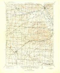
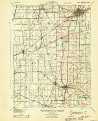
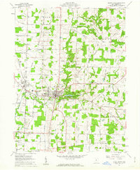
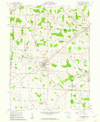
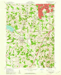
 1916 Mount Gilead1941 Print · USGSMorrow and Crawford counties are shown here just before the First World War, when rail lines and rural schools defined the Ohio countryside. Genealogists can locate family-named sites like Miller Cem or schools such as Dice School and Hog Swamp School.
 - 1924 Map of Delaware, 1954 Print
 1924 Delaware1954 Print · USGSDelaware and its surrounding townships thrive in the mid-twenties as vital rail and river hubs. Researchers can trace the heritage of rural communities through dozens of local landmarks like Cherry Ridge School, Bethlehem Church, and Warrensburg.
 - 1925 Map of Delaware, 1940 Print
 1925 Delaware1940 Print · USGSCentral Ohio in the mid-1920s is defined by its vibrant river valleys and shifting rail corridors. Genealogists can trace family roots through numerous country schools like Schoor School, rural parishes such as St James Church, and early settlements like Ostrander and Radnor.
 - 1943 Map of Shauck
 1943 Shauck1943 Print · USGSNorth Central Ohio is captured here in the mid-1940s, showing a landscape of small agricultural hamlets and a dense network of country schools. Genealogists and researchers can trace local landmarks like Johnsville Shauck P O, Chestnut Chapel, and the Erie RR corridor.
 - 1943 Map of Marengo
 1943 Marengo1943 Print · USGSCentral Ohio's agricultural heartland is documented here during the early war years, showing a landscape defined by small-town rail hubs and a dense network of rural schoolhouses. Researchers can trace family history through dozens of named sites like Chestnut Grove Sch, the County Infirmary, and settlements such as Westfield and Fulton.
 - 1943 Map of Mount Gilead
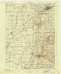
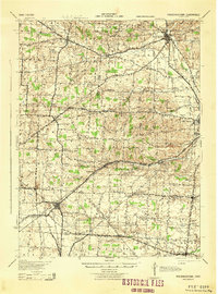
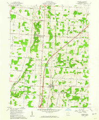
 1943 Mount Gilead1943 Print · USGSIn the early 1940s, this pocket of north-central Ohio remained a landscape of rail-connected towns and country school districts. Researchers can trace the rural heritage of Galion and Mount Gilead while locating landmarks like Miller Cem and the Guiding Star Sch.
 - 1943 Map of Fredericktown
 1943 Fredericktown1943 Print · USGSRural Knox County is captured here in the 1940s, showing a landscape of small townships connected by the Baltimore and Ohio RR and local schoolhouse districts. Genealogists can trace family footprints at Woodland Hall Sch, Bethel Ch, and ancient landmarks like Raleigh Mound.
 - 1944 Map of Delaware
 1944 Delaware1944 Print · USGSCentral Ohio during the Second World War shows a landscape of busy rail corridors and small crossroads settlements along the Scioto River. Genealogists can trace family roots through numerous country schools like Drumm Sch and landmarks such as Newhouse Cemetery.
 - 1950 Map of Marion
 1950 Marion1950 Print · USGSCentral Ohio was a powerhouse of rail and river industry at the mid-century point, serving as a vital corridor between the Great Lakes and the Ohio River valley. Genealogists and rail historians can trace the paths of the Erie RR and Nickel Plate Road through towns like Bucyrus, Galion, and Upper Sandusky.
 - 1960 Map of Galion, 1962 Print
 1960 Galion1962 Print · USGSMid-century Galion is captured here at the height of its rail-hub importance, where the major lines of the Midwest intersect. Genealogists and local historians can trace rural family plots like Autin Cem and Garverick Cem or explore early village life in Iberia and St James.3 unique versions available
 - 1961 Map of Blooming Grove, 1962 Print
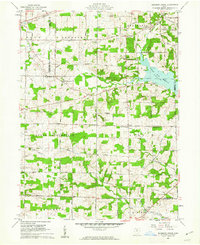 1961 Blooming Grove1962 Print · USGSThe borderlands of Morrow and Richland counties are captured here in the early sixties as the Clear Fork Reservoir shapes the landscape. Family historians can trace small crossroads communities like Blooming Grove, Steam Corners, and Jugs Corners, along with local burial sites including Red Squirrel Cem.4 unique versions available
 - 1961 Map of Kilbourne, 1962 Print
 1961 Kilbourne1962 Print · USGSDelaware and Morrow counties are shown here in the early sixties as a network of rural townships and winding creek valleys. Genealogists can locate family landmarks like Old Kilbourne Cem, Stantontown Cem, and the old County Home.4 unique versions available
 - 1961 Map of Mount Gilead, 1962 Print
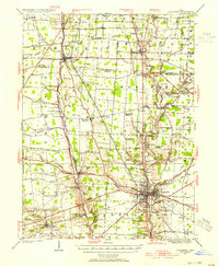
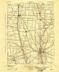
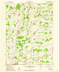
 1961 Mount Gilead1962 Print · USGSMorrow County farmland surrounds the village of Mount Gilead in the early sixties, showing a landscape defined by traditional townships and the New York Central line. Researchers can locate numerous family cemeteries like Moffit Cem and landmarks such as the County Home and Fairground.3 unique versions available
 - 1961 Map of Chesterville, 1962 Print
 1961 Chesterville1962 Print · USGSMorrow and Knox counties are shown here in the early 1960s, documenting a landscape of rural crossroads and river valleys. Researchers can trace ancestral locations through several family-named junctions like Bowen Corners and old church sites such as Harmony Chapel.2 unique versions available
 - 1961 Map of Centerburg, 1962 Print
 1961 Centerburg1962 Print · USGSKnox County is captured at the start of the 1960s, centered on the strategic rail junction at Centerburg. Genealogists and local historians can trace family plots at Houck Cem and Moreland Cem or locate old community landmarks like Milford Ch and Rich Hill.3 unique versions available
 - 1961 Map of Olive Green, 1962 Print
 1961 Olive Green1962 Print · USGSCentral Ohio farm country comes to life in the early 1960s, showing a landscape of small crossroads and creek-side settlements. Researchers can trace the path of the Pennsylvania railroad or locate rural landmarks like the Covered Bridge and Pagetown Cem.3 unique versions available
 - 1961 Map of Marengo, 1962 Print
 1961 Marengo1962 Print · USGSMorrow County is captured in the early sixties as a patchwork of productive farmland and timbered creek bottoms. Researchers can trace the path of the New York Central railroad and locate family landmarks like Benedict Church and Marengo Cem.2 unique versions available
 - 1961 Map of Shauck, 1962 Print
 1961 Shauck1962 Print · USGSThe rural border of Morrow and Knox counties is captured here in the early sixties, showing a landscape of scattered farmsteads and small crossroads. Genealogists can trace family landmarks like Pleasant Grove Ch, Pulaskiville, and Shauck.4 unique versions available
 - 1961 Map of Caledonia, 1962 Print
 1961 Caledonia1962 Print · USGSAgricultural life in Marion and Crawford counties is captured here in the early sixties, as rail lines still linked small rural hubs. Trace family history through Monnett Chapel, Rush Cem, and the rail junction at Caledonia.2 unique versions available
 - 1961 Map of Mansfield South, 1962 Print
 1961 Mansfield South1962 Print · USGSRichland County at the start of the sixties shows a landscape of growing suburbs and rural crossroads. Researchers can trace the expansion of Mansfield south toward Lexington or locate family sites near Hilton Ch and Kings Corners.5 unique versions available
 - 1961 Map of Bellville, 1962 Print
 1961 Bellville1962 Print · USGSRichland and Knox counties in the early sixties remain defined by their historic survey boundaries and rural crossroads. Genealogists and historians can trace family roots through sites like Strong Cem, the Lutheran Ch, and small rail-side settlements like Ankenytown.3 unique versions available
Showing maps 1-25 of 110
Frequently asked questions
- What are the different types of historical maps available for Morrow County?
- What is the oldest map of Morrow County?
- Where can I purchase historical maps of Morrow County for my home or office?
- Where can I download high-res historical maps of Morrow County?
- Are there historical topographic maps available for Morrow County?
- Is there historical aerial imagery available for Morrow County?
- Where are historical maps of Morrow County sourced from?