1990s Maps of Sue-Lin Acres, Ohio
Explore 1 historic maps of Sue-Lin Acres from the 1990s. These maps offer a rare glimpse into what life looked like during the 1990s — showing old roads, neighborhoods, homes, and landmarks that have changed or disappeared over time.
Whether you're researching your family's past, planning a metal detecting trip, or studying how Sue-Lin Acres's landscape evolved across the 1990s, these high-resolution maps are a powerful tool for exploring the history of this region.
- Focus on a specific era: All maps on this page are from the 1990s, giving you a focused view of this time period.
- See what’s changed: Compare century-old streets, trails, and buildings to today's modern landscape using overlays and satellite layers.
- Research with precision: Use these maps for genealogy, historical research, land use analysis, or educational projects.
- View, download, or print: Maps are fully viewable online in high resolution, and can be downloaded or printed for your own records.
Start exploring Sue-Lin Acres's history through authentic maps from the 1990s. This is your window into the past.
Sue-Lin Acres, OH maps
(1)- 1994 Map of Quaker City, 1998 Print
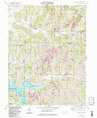 1994 Quaker City1998 Print · USGSEastern Ohio hill country in the mid-nineties shows a landscape defined by pioneer survey lines and mineral extraction. Trace family sites near Salesville, Batesville, and the Richland Meetinghouse or follow the waters of Senecaville Lake.
End of results
Showing maps 1-1 of 1
Top cities near Sue-Lin Acres
- Cambridge historical maps
- Barnesville historical maps
- Byesville historical maps
- Woodsfield historical maps
- Caldwell historical maps
- Center historical maps
See more
Frequently asked questions
- What are the different types of historical maps available for Sue-Lin Acres?
- What is the oldest map of Sue-Lin Acres?
- Where can I purchase historical maps of Sue-Lin Acres for my home or office?
- Where can I download high-res historical maps of Sue-Lin Acres?
- Are there historical topographic maps available for Sue-Lin Acres?
- Is there historical aerial imagery available for Sue-Lin Acres?
- Where are historical maps of Sue-Lin Acres sourced from?