1910s Maps of Waverly Gables, Pee Pee Township
Explore 2 historic maps of Waverly Gables from the 1910s. These maps offer a rare glimpse into what life looked like during the 1910s — showing old roads, neighborhoods, homes, and landmarks that have changed or disappeared over time.
Whether you're researching your family's past, planning a metal detecting trip, or studying how Waverly Gables's landscape evolved across the 1910s, these high-resolution maps are a powerful tool for exploring the history of this region.
- Focus on a specific era: All maps on this page are from the 1910s, giving you a focused view of this time period.
- See what’s changed: Compare century-old streets, trails, and buildings to today's modern landscape using overlays and satellite layers.
- Research with precision: Use these maps for genealogy, historical research, land use analysis, or educational projects.
- View, download, or print: Maps are fully viewable online in high resolution, and can be downloaded or printed for your own records.
Start exploring Waverly Gables's history through authentic maps from the 1910s. This is your window into the past.
Waverly Gables, Pee Pee Township maps
(2)- 1915 Map of Piketon, 1959 Print
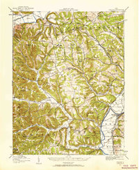 1915 Piketon1959 Print · USGSPike and Ross Counties are shown in the mid-1910s during a height of rural settlement and local industry. Genealogists can locate dozens of country schoolhouses like Yankee Hill School and vanished post offices such as Bethel Pike PO.
 - 1917 Map of Piketon, 1934 Print
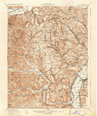 1917 Piketon1934 Print · USGSThe Scioto River valley and its surrounding hill country are captured here during the first World War era, showing a landscape of small farmsteads and ancient earthworks. Genealogists can trace family roots through dozens of named rural landmarks like Seip Mound, Bethel Pike PO, and Mound Cemetery.2 unique versions available
End of results
Showing maps 1-2 of 2
Frequently asked questions
- What are the different types of historical maps available for Waverly Gables?
- What is the oldest map of Waverly Gables?
- Where can I purchase historical maps of Waverly Gables for my home or office?
- Where can I download high-res historical maps of Waverly Gables?
- Are there historical topographic maps available for Waverly Gables?
- Is there historical aerial imagery available for Waverly Gables?
- Where are historical maps of Waverly Gables sourced from?