1990s Maps of Portage County, Ohio
Explore 17 historic maps of Portage County from the 1990s. These maps offer a rare glimpse into what life looked like during the 1990s — showing old roads, neighborhoods, homes, and landmarks that have changed or disappeared over time.
Whether you're researching your family's past, planning a metal detecting trip, or studying how Portage County's landscape evolved across the 1990s, these high-resolution maps are a powerful tool for exploring the history of this region.
- Focus on a specific era: All maps on this page are from the 1990s, giving you a focused view of this time period.
- See what’s changed: Compare century-old streets, trails, and buildings to today's modern landscape using overlays and satellite layers.
- Research with precision: Use these maps for genealogy, historical research, land use analysis, or educational projects.
- View, download, or print: Maps are fully viewable online in high resolution, and can be downloaded or printed for your own records.
Start exploring Portage County's history through authentic maps from the 1990s. This is your window into the past.
Portage County, OH maps
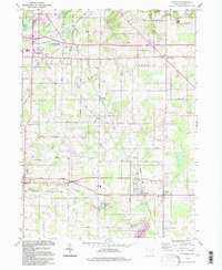
(17)- 1994 Map of Cleveland South
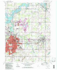
 1994 Cleveland South1994 Print · USGSThe metropolitan corridor between Akron and Cleveland is shown here in the mid-nineties during a period of significant suburban growth. Researchers can trace the path of the Ohio Turnpike or explore expansive recreation lands like West Branch State Park.
 - 1994 Map of Alliance, 1997 Print
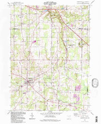
 1994 Alliance1997 Print · USGSThe Mahoning Valley industrial corridor and the campus of Mt Union College are captured here in the 1990s. Trace local history through family-named cemeteries like Hartzell Cem and old rail stops at North Benton Sta.
 - 1994 Map of Kent, 1997 Print
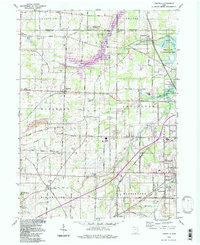
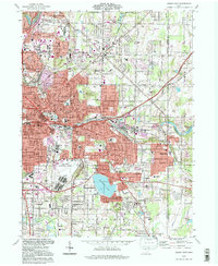
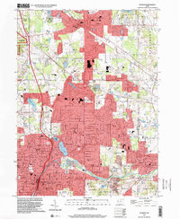
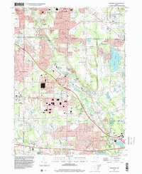
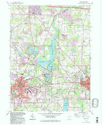 1994 Kent1997 Print · USGSPortage County in the mid-nineties shows a landscape shaped by glacial waters and academic growth. Trace family and local history at Standing Rock Cem, Kent State University, and the unique Kent Bog State Nature Preserve.
 - 1994 Map of Mantua, 1997 Print
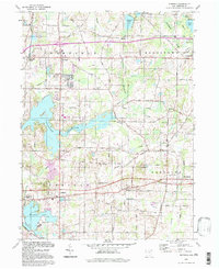
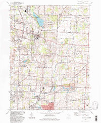
 1994 Mantua1997 Print · USGSPortage County in the mid-nineties remains a landscape of historic academic centers and preserved river corridors. Researchers can trace family roots at Westlawn Cem, explore the grounds of Hiram College, or locate the old Hiram Rapids settlement.
 - 1994 Map of Suffield, 1997 Print
 1994 Suffield1997 Print · USGSPortage County at the close of the twentieth century remains a landscape of traditional township centers and significant water features. Researchers can trace local heritage through the Blimp Landing Field, St Michaels Ch, and the Upson-Meacham Cem.
 - 1994 Map of North Canton, 1997 Print
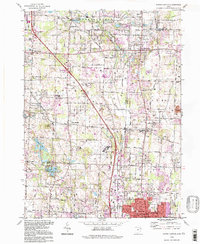 1994 North Canton1997 Print · USGSThe crossroads of the historic Western Reserve and Congress Lands are revealed in this detailed survey of the corridor between Akron and Canton in the late twentieth century. Researchers can locate ancestral sites including Greensburg Cem, Millroy Sch, and the community of Uniontown.
 - 1994 Map of Atwater, 1997 Print
 1994 Atwater1997 Print · USGSPortage County in the 1990s remained a landscape of quiet township centers and productive farmland. You can trace early settlement patterns and family history at Edinburg Cem, the station at New Milford, and the small community of Industry.
 - 1994 Map of Garrettsville, 1997 Print
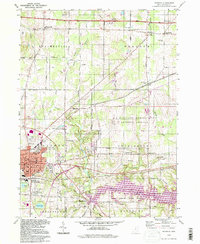
 1994 Garrettsville1997 Print · USGSGarrettsville and the surrounding townships of Portage and Geauga counties are captured here in the late twentieth century. Genealogists and local historians can trace family-named sites like Abbot Cem and Harrington Cem or explore the distinct geology of Nelson Ledge.
 - 1994 Map of Limaville, 1997 Print
 1994 Limaville1997 Print · USGSStark and Portage counties meet here in the 1990s, where rural township grids intersect with large-scale water management projects. Genealogists can locate family sites like Marlboro Cem and Quaker Hill Cem, while historians can trace the Conrail line through Lexington and Maximo.
 - 1994 Map of Hartville, 1997 Print
 1994 Hartville1997 Print · USGSNortheastern Ohio’s rural character and shifting land use are on full display in the 1990s as family farms meet growing recreation areas. Genealogists and local historians can locate early foundations at the Walnut Grove Sch Cem, East Nimishillen Ch, and the hamlet of Mishler.
 - 1994 Map of Akron East, 1997 Print
 1994 Akron East1997 Print · USGSEastern Akron and its neighbors in the mid-1990s show a region shaped by industry and aviation. Researchers can trace local history at the Goodyear Airdock, Tallmadge Cemetery, and the shores of Springfield Lake.
 - 1994 Map of Aurora, 1997 Print
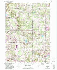 1994 Aurora1997 Print · USGSNortheastern Ohio townships near the turn of the millennium show a landscape of growing communities and protected waterways. You can trace early school sites like Waite Sch and recreation areas such as Geauga Lake or the Upper Cuyahoga State Scenic River.
 - 1994 Map of Windham, 1997 Print
 1994 Windham1997 Print · USGSPortage and Trumbull counties are shown in the 1990s as a landscape shaped by military infrastructure and rural rail-and-river networks. Researchers can trace the massive Ravenna Arsenal, find old burial sites like St Josephs Cem, and locate the waters of Kirwan Reservoir.
 - 1994 Map of Deerfield, 1997 Print
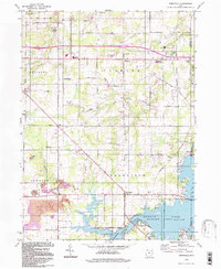 1994 Deerfield1997 Print · USGSPortage County at the close of the twentieth century shows a landscape shaped by the waters of Berlin Lake and long-standing rural townships. Researchers can trace family sites at Mottown Cem, locate the old Akron YWCA Camp, or find historic coal works at the Strip Mine.
 - 1994 Map of Ravenna, 1997 Print
 1994 Ravenna1997 Print · USGSPortage County at the close of the century shows a unique mix of civic expansion and massive military infrastructure. Genealogists can trace family sites near Maple Grove Cem and Highland Sch, or explore the sprawling U S Military Reservation Ravenna Arsenal.
 - 1994 Map of Hudson, 2000 Print
 1994 Hudson2000 Print · USGSNortheast Ohio's suburban landscape comes into focus during the 1990s as the cities of Hudson and Stow expand toward the Cuyahoga Valley. Genealogists and local historians can trace legacy sites like Western Reserve Academy and Markillie Cem amidst the era's growing neighborhoods.
 - 1994 Map of Twinsburg, 2000 Print
 1994 Twinsburg2000 Print · USGSThe northern reaches of Summit and Cuyahoga counties are shown here as suburban expansion began to reshape the old Western Reserve. Researchers can trace the layout of Geauga Lake, find the location of Locust Grove Cem, or locate the stop at Falls Junction.
End of results
Showing maps 1-17 of 17
Top cities of Portage County
- Kent historical maps
- Streetsboro historical maps
- Aurora historical maps
- Ravenna historical maps
- Windham historical maps
- Garrettsville historical maps
See more
Frequently asked questions
- What are the different types of historical maps available for Portage County?
- What is the oldest map of Portage County?
- Where can I purchase historical maps of Portage County for my home or office?
- Where can I download high-res historical maps of Portage County?
- Are there historical topographic maps available for Portage County?
- Is there historical aerial imagery available for Portage County?
- Where are historical maps of Portage County sourced from?