1990s Maps of Atwater Township, Ohio
Explore 5 historic maps of Atwater Township from the 1990s. These maps offer a rare glimpse into what life looked like during the 1990s — showing old roads, neighborhoods, homes, and landmarks that have changed or disappeared over time.
Whether you're researching your family's past, planning a metal detecting trip, or studying how Atwater Township's landscape evolved across the 1990s, these high-resolution maps are a powerful tool for exploring the history of this region.
- Focus on a specific era: All maps on this page are from the 1990s, giving you a focused view of this time period.
- See what’s changed: Compare century-old streets, trails, and buildings to today's modern landscape using overlays and satellite layers.
- Research with precision: Use these maps for genealogy, historical research, land use analysis, or educational projects.
- View, download, or print: Maps are fully viewable online in high resolution, and can be downloaded or printed for your own records.
Start exploring Atwater Township's history through authentic maps from the 1990s. This is your window into the past.
Atwater Township, OH maps
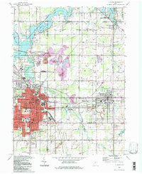
(5)- 1994 Map of Cleveland South
 1994 Cleveland South1994 Print · USGSThe metropolitan corridor between Akron and Cleveland is shown here in the mid-nineties during a period of significant suburban growth. Researchers can trace the path of the Ohio Turnpike or explore expansive recreation lands like West Branch State Park.
 - 1994 Map of Alliance, 1997 Print
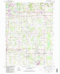
 1994 Alliance1997 Print · USGSThe Mahoning Valley industrial corridor and the campus of Mt Union College are captured here in the 1990s. Trace local history through family-named cemeteries like Hartzell Cem and old rail stops at North Benton Sta.
 - 1994 Map of Atwater, 1997 Print
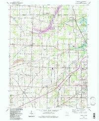
 1994 Atwater1997 Print · USGSPortage County in the 1990s remained a landscape of quiet township centers and productive farmland. You can trace early settlement patterns and family history at Edinburg Cem, the station at New Milford, and the small community of Industry.
 - 1994 Map of Limaville, 1997 Print
 1994 Limaville1997 Print · USGSStark and Portage counties meet here in the 1990s, where rural township grids intersect with large-scale water management projects. Genealogists can locate family sites like Marlboro Cem and Quaker Hill Cem, while historians can trace the Conrail line through Lexington and Maximo.
 - 1994 Map of Deerfield, 1997 Print
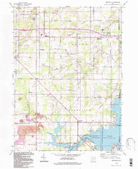 1994 Deerfield1997 Print · USGSPortage County at the close of the twentieth century shows a landscape shaped by the waters of Berlin Lake and long-standing rural townships. Researchers can trace family sites at Mottown Cem, locate the old Akron YWCA Camp, or find historic coal works at the Strip Mine.
End of results
Showing maps 1-5 of 5
Top cities near Atwater Township
- Canton historical maps
- Plain historical maps
- Kent historical maps
- Alliance historical maps
- North Canton historical maps
- Streetsboro historical maps
See more
Top neighborhoods of Atwater Township
Frequently asked questions
- What are the different types of historical maps available for Atwater Township?
- What is the oldest map of Atwater Township?
- Where can I purchase historical maps of Atwater Township for my home or office?
- Where can I download high-res historical maps of Atwater Township?
- Are there historical topographic maps available for Atwater Township?
- Is there historical aerial imagery available for Atwater Township?
- Where are historical maps of Atwater Township sourced from?