1960s Maps of Kent, Ohio
Explore 5 historic maps of Kent from the 1960s. These maps offer a rare glimpse into what life looked like during the 1960s — showing old roads, neighborhoods, homes, and landmarks that have changed or disappeared over time.
Whether you're researching your family's past, planning a metal detecting trip, or studying how Kent's landscape evolved across the 1960s, these high-resolution maps are a powerful tool for exploring the history of this region.
- Focus on a specific era: All maps on this page are from the 1960s, giving you a focused view of this time period.
- See what’s changed: Compare century-old streets, trails, and buildings to today's modern landscape using overlays and satellite layers.
- Research with precision: Use these maps for genealogy, historical research, land use analysis, or educational projects.
- View, download, or print: Maps are fully viewable online in high resolution, and can be downloaded or printed for your own records.
Start exploring Kent's history through authentic maps from the 1960s. This is your window into the past.
Kent, OH maps
(5)- 1960 Map of Kent, 1961 Print
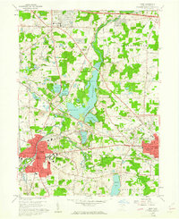 1960 Kent1961 Print · USGSMid-century Portage County is defined here by the industrial growth of Kent and the sprawling waters of Lake Rockwell. Genealogists can trace family names through Standing Rock Cem and Streetsboro Cem or locate early campus buildings at Kent State University.5 unique versions available
 - 1960 Map of Suffield, 1961 Print
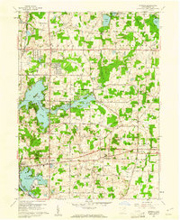 1960 Suffield1961 Print · USGSPortage County in the early sixties shows a landscape of glacial lakes and growing townships centered around the Connecticut Western Reserve. Local researchers can trace the Blimp Landing Field near Suffield or locate family plots at North Dyke Cem and Randolph Hillside Cem.2 unique versions available
 - 1962 Map of Cleveland
 1962 Cleveland1962 Print · USGSNortheast Ohio and the Pennsylvania borderlands appear here during the industrial peak of the early sixties. Genealogists and historians can trace the expansive rail lines of the Nickel Plate Road and the growth of suburbs from Parma to Lyndhurst.
 - 1963 Map of Hudson, 1964 Print
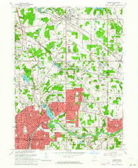 1963 Hudson1964 Print · USGSNortheastern Ohio’s suburban landscape comes into focus in the early sixties as the cities of the Cuyahoga Valley expand. Genealogists can locate family sites at Markillie Cem or Draper Cem, and trace the grounds of Western Reserve Academy or the quiet settlement of Darrowville.4 unique versions available
 - 1967 Map of Akron East, 1969 Print
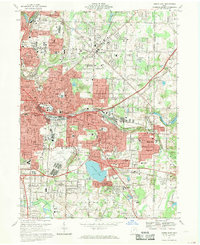 1967 Akron East1969 Print · USGSSummit County's industrial heart and growing suburbs are captured here during the late sixties. Trace the footprint of aviation history at the Goodyear Airdock and explore the rail networks of the Erie-Lackawanna RR and Penn Central.6 unique versions available
End of results
Showing maps 1-5 of 5
Top cities near Kent
- Akron historical maps
- Cuyahoga Falls historical maps
- Stow historical maps
- Green historical maps
- Barberton historical maps
- Solon historical maps
See more
Top neighborhoods of Kent
- Science Mall historical maps
- Oak Hills historical maps
- Centennial Court historical maps
- The Quad historical maps
- Downtown historical maps
- University Woods historical maps
See more
Frequently asked questions
- What are the different types of historical maps available for Kent?
- What is the oldest map of Kent?
- Where can I purchase historical maps of Kent for my home or office?
- Where can I download high-res historical maps of Kent?
- Are there historical topographic maps available for Kent?
- Is there historical aerial imagery available for Kent?
- Where are historical maps of Kent sourced from?