1910s Maps of Anderson, Ross County
Explore 2 historic maps of Anderson from the 1910s. These maps offer a rare glimpse into what life looked like during the 1910s — showing old roads, neighborhoods, homes, and landmarks that have changed or disappeared over time.
Whether you're researching your family's past, planning a metal detecting trip, or studying how Anderson's landscape evolved across the 1910s, these high-resolution maps are a powerful tool for exploring the history of this region.
- Focus on a specific era: All maps on this page are from the 1910s, giving you a focused view of this time period.
- See what’s changed: Compare century-old streets, trails, and buildings to today's modern landscape using overlays and satellite layers.
- Research with precision: Use these maps for genealogy, historical research, land use analysis, or educational projects.
- View, download, or print: Maps are fully viewable online in high resolution, and can be downloaded or printed for your own records.
Start exploring Anderson's history through authentic maps from the 1910s. This is your window into the past.
Anderson, Ross County maps
(2)- 1912 Map of Roxabell, 1958 Print
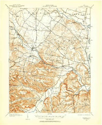 1912 Roxabell1958 Print · USGSRoss County was a landscape of river-valley agriculture and early rail commerce just before the First World War. Genealogists can locate dozens of country schoolhouses like Mallow School and trace the path of the abandoned Ohio and Erie Canal.
 - 1914 Map of Roxabell, 1942 Print
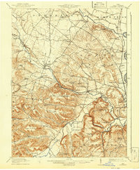 1914 Roxabell1942 Print · USGSRoss County was a landscape of rail junctions and rural schoolhouses just before the Great War. Genealogists can trace family names across Plyley Ridge and locate dozens of local landmarks like Egypt Church, Mallow School, and the prehistoric Indian Mound near Deer Creek.
End of results
Showing maps 1-2 of 2
Frequently asked questions
- What are the different types of historical maps available for Anderson?
- What is the oldest map of Anderson?
- Where can I purchase historical maps of Anderson for my home or office?
- Where can I download high-res historical maps of Anderson?
- Are there historical topographic maps available for Anderson?
- Is there historical aerial imagery available for Anderson?
- Where are historical maps of Anderson sourced from?