Old Maps of Ross County, Ohio
Explore 176 old maps of Ross County, spanning from 1906 to today. These high-resolution historic maps reveal how streets, neighborhoods, landmarks, and natural features evolved over time — perfect for genealogy, metal detecting, research, and local history exploration.
What you can do with these maps:
- See how Ross County changed over time: Compare historical maps to modern-day views to trace roads, homesites, rail lines & more.
- View detailed metadata: Each map includes creators, publishers, year, scale, and archive source.
- Overlay maps with satellite & LiDAR: Visualize the past alongside modern tools to explore terrain & human change.
- Trusted historical sources: Maps sourced from the USGS, Library of Congress, and other archives.
- Access maps your way: View online, download high-res files, or order prints for personal or research use.
Start exploring old maps of Ross County to uncover forgotten places, hidden landmarks, and the deep history beneath your feet.
Ross County, OH maps
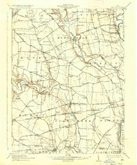
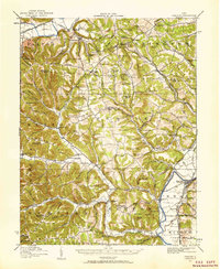
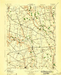
(176)- 1906 Map of Waverly
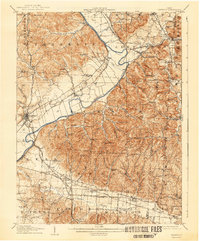
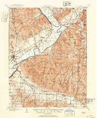 1906 Waverly1906 Print · USGSSouthern Ohio at the turn of the century shows a bustling corridor of river valleys and rail junctions centered on Waverly. Genealogists and historians can trace defunct post offices like Stony Creek Sta Pride PO and rural landmarks like Lilly Chapel or Cars Run School.
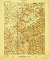
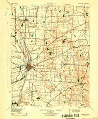
 - 1906 Map of Mt Sterling, 1946 Print
 1906 Mt Sterling1946 Print · USGSCentral Ohio at the start of the twentieth century is a landscape of thriving rail hubs and rural townships. Trace the convergence of five railroads at Washington Courthouse and find family landmarks like the County Infirmary or Bloomingburg.
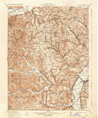
 - 1906 Map of Chillicothe, 1954 Print
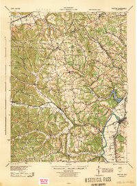
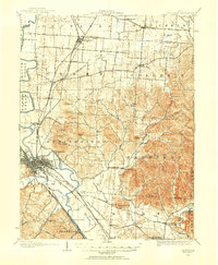 1906 Chillicothe1954 Print · USGSIn the early 1900s, this area of south-central Ohio was defined by a complex intersection of major railroads and river valleys. Researchers can trace the development of Chillicothe or locate ancestral sites at Londonderry, Bethel Chapel, and the County Infirmary.
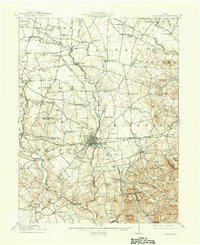
 - 1908 Map of Chillicothe, 1943 Print
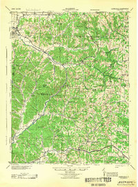
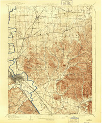 1908 Chillicothe1943 Print · USGSChillicothe and its surrounding rural townships thrive at a turn-of-the-century crossroads of river and rail. Trace old family landmarks and institutions like Mount Logan, Bethel Chapel, and the County Infirmary across Ross and Pickaway counties.
 - 1908 Map of Waverly, 1944 Print
 1908 Waverly1944 Print · USGSThe Scioto River valley at the start of the twentieth century was a vital crossroads of five competing railroads. Local historians can trace early mail stops like Robbins Dove PO and rural landmarks such as Lily Chapel or Meadow Run Church.
 - 1910 Map of Laurelville, 1962 Print
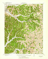 1910 Laurelville1962 Print · USGSHocking and Vinton counties come alive in the decade before the First World War, showing a landscape of ridge-top farms and valley hamlets. Genealogists can locate family landmarks like Eagle Mills, the Indian Mound, and dozens of schools including Tuling School and Union School.
 - 1911 Map of Era, 1952 Print
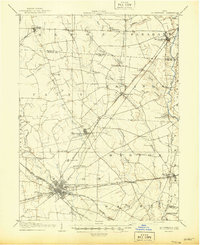
 1911 Era1952 Print · USGSPickaway County at the start of the 1900s is a landscape of established farmsteads and creekside milling. Genealogists can trace family footprints through numerous rural school sites like Tick Ridge School or Locust Grove School and find early commerce hubs like Crownover Mill and Williamsport.
 - 1912 Map of Laurelville, 1939 Print
 1912 Laurelville1939 Print · USGSHocking and Vinton counties at the dawn of the twentieth century show a landscape of ridge-top schools and creek-side settlements. Researchers can trace the path of the Columbus and Southern RR (Abandoned) and locate landmarks like Ash Cave and the Indian Mound.2 unique versions available
 - 1912 Map of Roxabell, 1958 Print
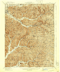
 1912 Roxabell1958 Print · USGSRoss County was a landscape of river-valley agriculture and early rail commerce just before the First World War. Genealogists can locate dozens of country schoolhouses like Mallow School and trace the path of the abandoned Ohio and Erie Canal.
 - 1913 Map of Era, 1936 Print
 1913 Era1936 Print · USGSPickaway County agricultural life and early transport networks are preserved here in the years before the Great War. Genealogists and local historians can locate dozens of country schoolhouses like Dublin Hill School and river crossings such as Becks Ford and Gulicks Ford.
 - 1914 Map of Roxabell, 1942 Print
 1914 Roxabell1942 Print · USGSRoss County was a landscape of rail junctions and rural schoolhouses just before the Great War. Genealogists can trace family names across Plyley Ridge and locate dozens of local landmarks like Egypt Church, Mallow School, and the prehistoric Indian Mound near Deer Creek.
 - 1914 Map of Circleville, 1948 Print
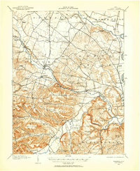
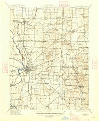 1914 Circleville1948 Print · USGSThe Scioto River valley and Pickaway Plains are captured here during a period of thriving rail commerce and rural schoolhouse districts. Researchers can find ancestral sites from the Reber Hill Cemetery to vanished stops along the Scioto Valley and New England RR.
 - 1915 Map of Bainbridge
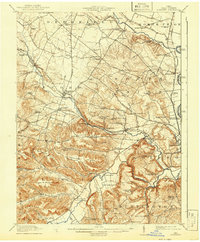
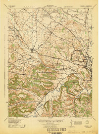
 1915 Bainbridge1915 Print · USGSBefore the modernization of rural Ohio, this 1915 survey captures Highland and Ross counties when one-room schoolhouses and country churches anchored every ridge. Trace family roots at Bainbridge, find the Indian Mound on Paint Creek, or locate Fall Creek Church and Redkey School.2 unique versions available
 - 1915 Map of Piketon, 1959 Print
 1915 Piketon1959 Print · USGSPike and Ross Counties are shown in the mid-1910s during a height of rural settlement and local industry. Genealogists can locate dozens of country schoolhouses like Yankee Hill School and vanished post offices such as Bethel Pike PO.
 - 1917 Map of Bainbridge
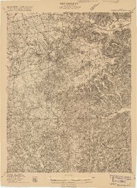
 1917 Bainbridge1917 Print · USGSIn the decade before modern highways, this Ohio highland region was a land of ridge-top schools and creek-side mills. Genealogists and historians can locate numerous rural schoolhouses like Walnut Shade School and ancient landmarks including the famous Serpent Mound.4 unique versions available
 - 1917 Map of Piketon, 1934 Print
 1917 Piketon1934 Print · USGSThe Scioto River valley and its surrounding hill country are captured here during the first World War era, showing a landscape of small farmsteads and ancient earthworks. Genealogists can trace family roots through dozens of named rural landmarks like Seip Mound, Bethel Pike PO, and Mound Cemetery.2 unique versions available
 - 1917 Map of Greenfield, 1937 Print
 1917 Greenfield1937 Print · USGSSouthern Ohio at the start of the Great War was a network of rail-side towns and rural school districts. Genealogists can trace family roots through numerous local landmarks like Rock Mills, South Salem, and dozens of named schoolhouses such as Sunshine School.2 unique versions available
 - 1943 Map of Era
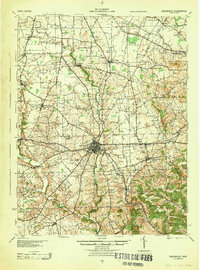
 1943 Era1943 Print · USGSPickaway and Ross Counties are shown in the early 1940s, a period when rural education and river-based land divisions still shaped the Ohio countryside. Genealogists can locate dozens of country schoolhouses like Frogeye Sch and trace the Pennsylvania rail line through Williamsport and Atlanta.
 - 1943 Map of Circleville
 1943 Circleville1943 Print · USGSMid-century Pickaway County is defined here by its intersection of rail power and ancient landmarks along the Scioto River. Genealogists and historians can trace dozens of rural schoolhouses like Bushwhack Sch, the county Infirmary, and the site of the Logan Elm.
 - 1944 Map of Piketon
 1944 Piketon1944 Print · USGSSouthern Ohio's hill country meets the Scioto River valley in the mid-1940s, a landscape defined by ancient earthworks and rugged ridge-top schoolhouses. Researchers can locate family landmarks like the County Home, trace the Norfolk and Western RR, or find vanished community hubs like Bethel Pike PO and Morgantown.
 - 1944 Map of Laurelville
 1944 Laurelville1944 Print · USGSMid-century Hocking and Vinton Counties appear here as a patchwork of tight-knit upland communities during the Second World War. Researchers can locate dozens of local landmarks including Adelphi, Eagle Mills, and the Chestnut Grove Church nestled among the hollows.
 - 1944 Map of Greenfield
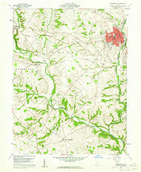
 1944 Greenfield1944 Print · USGSMid-century Highland and Ross Counties center on the rail crossroads of Greenfield during the final years of the war. Genealogists can trace rural family life through dozens of named schoolhouses like Pikes Peak Sch and early settlements such as South Salem or Good Hope.
 - 1944 Map of Roxabell
 1944 Roxabell1944 Print · USGSRoss County during the mid-forties reveals a rural landscape defined by ancient earthworks and modern military mobilization. Genealogists and historians can locate dozens of country schools like Metzger Sch and Cline Sch alongside the Camp Sherman Military Reservation.
 - 1947 Map of Columbus, 1948 Print
 1947 Columbus1948 Print · USGSCentral Ohio in the late 1940s is captured in this survey, showing the post-war transition of its rail hubs and military airfield expansions. Genealogists and historians can trace the paths of the Ohio Canal, the Pennsylvania RR lines, and the Camp Sherman Military Reservation.
 - 1960 Map of Greenfield, 1962 Print
 1960 Greenfield1962 Print · USGSThe industrial and rail crossroads of GREENFIELD are captured here in the early 1960s at the junction of two major rail lines. Genealogists can trace family roots through numerous rural sites like Rocky Spring Cem, New Petersburg, and McClain High Sch.3 unique versions available
Showing maps 1-25 of 176
Top cities of Ross County
- Chillicothe historical maps
- Bainbridge historical maps
- Frankfort historical maps
- Kingston historical maps
- Clarksburg historical maps
- Adelphi historical maps
See more
Frequently asked questions
- What are the different types of historical maps available for Ross County?
- What is the oldest map of Ross County?
- Where can I purchase historical maps of Ross County for my home or office?
- Where can I download high-res historical maps of Ross County?
- Are there historical topographic maps available for Ross County?
- Is there historical aerial imagery available for Ross County?
- Where are historical maps of Ross County sourced from?