1906 Map of Waverly
USGS Topo · Published 1906About this map
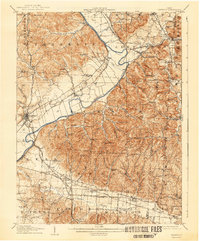
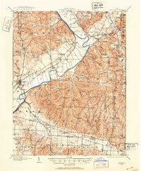
Waverly and the wide bottomlands of the Scioto River dominate this 1906 landscape, revealing a dense network of early 20th-century transportation and rural infrastructure. The region is heavily bisected by rail lines, including the Detroit Toledo and Ironon and the Western Ohio and Norfolk, which connect established settlements like Richmondale and Omega. The map provides significant genealogical value through its many specifically named churches and schools, such as Lilly Chapel, Beaver Chapel, and the Cars Run School. These institutions, along with small post offices like Stony Creek Sta Pride PO and Robbins Dove PO, trace the scattered social fabric of Pike and Ross counties before mid-century modernization shifted the local economy. Distinctive landmarks like Hermit Cave and Chimney Rocks appear alongside the winding courses of Salt Creek and Beaver Creek.
Find a feature on this map
100 named features on this map. Tap any name to fly to it.
Don’t see what you’re looking for? This feature index may not catch every label — zoom into the map to look around manually.
Map Details
Editions of this 1906 Waverly Map
This is the sole edition of this map. No revisions or reprints were ever made.