
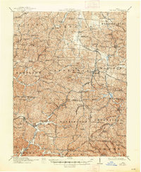
1912 Map of Oak Hill
USGS Topo · Published 1935About this map
The Jefferson Furnace and Bloom Furnace define the industrial character of this corner of southern Ohio, where the iron industry shaped the rugged landscape of Jefferson and Bloom townships. At this time, the region was a complex network of narrow valleys and ridges, with small mining and furnace settlements like Samsonville and Black Fork Sta connected by several railroads. The Baltimore and Ohio Southwestern RR and the Detroit Toledo and Ironton Railroad cut through the terrain, moving resources from the coal and iron operations to larger markets. This 1912 survey preserves the location of numerous country schools, such as Peachorchard School and White Bear School, and early religious centers like Moriah Church and Salem Church. The map captures a moment when the transition from traditional charcoal iron production to more modern industrial practices was still visible in the scattered furnaces and railroad switches like Globe Switch.
Find a feature on this map
120 named features on this map. Tap any name to fly to it.
Don’t see what you’re looking for? This feature index may not catch every label — zoom into the map to look around manually.
Map Details
Editions of this 1912 Oak Hill Map
2 editions found
Other maps of this area

1898 · Ironton
USGS Topo · 1:62,500

1900 · Ironton
USGS Topo · 1:62,500

1905 · Wilkesville
USGS Topo · 1:62,500

1906 · Waverly
USGS Topo · 1:62,500

1906 · Bidwell
USGS Topo · 1:62,500

1906 · Athalia
USGS Topo · 1:62,500

1908 · Bidwell
USGS Topo · 1:62,500

1908 · Athalia
USGS Topo · 1:62,500

1908 · Wilkesville
USGS Topo · 1:62,500

1908 · Waverly
USGS Topo · 1:62,500