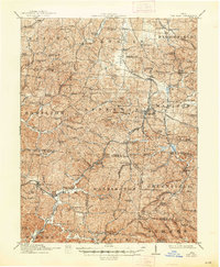
1912 Map of Oak Hill
USGS Topo · Published 1948About this map
Jefferson Furnace, Cambria Furnace, and Bloom Furnace stand as industrial anchors in this early twentieth-century survey of the rugged Jackson and Scioto County borderlands. The landscape is defined by the extraction and processing of natural resources, with the iron industry's footprint visible across the dissected plateaus. The Detroit Toledo and Ironton RR and the Baltimore and Ohio RR provide the critical transportation backbone, linking hilltop settlements and valley floor works.
Find a feature on this map
97 named features on this map. Tap any name to fly to it.
Don’t see what you’re looking for? This feature index may not catch every label — zoom into the map to look around manually.
Map Details
Editions of this 1912 Oak Hill Map
2 editions found

Other maps of this area

1898 · Ironton
USGS Topo · 1:62,500

1900 · Ironton
USGS Topo · 1:62,500

1905 · Wilkesville
USGS Topo · 1:62,500

1906 · Waverly
USGS Topo · 1:62,500

1906 · Bidwell
USGS Topo · 1:62,500

1906 · Athalia
USGS Topo · 1:62,500

1908 · Bidwell
USGS Topo · 1:62,500

1908 · Athalia
USGS Topo · 1:62,500

1908 · Wilkesville
USGS Topo · 1:62,500

1908 · Waverly
USGS Topo · 1:62,500