1908 Map of Waverly
USGS Topo · Published 1944About this map
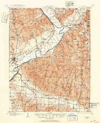
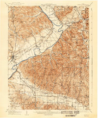
Scioto River dominates the landscape of southern Ohio at the turn of the century, serving as a primary corridor for both water and rail transportation. This 1905–1906 survey reveals a complex network of five major railroads, including the Norfolk and Western Ry and the Baltimore and Ohio Southwestern RR, which bisect the valley near Waverly. The map illustrates a rural society organized around small post offices and neighborhood institutions, such as Robbins Dove PO and Stony Creek Sta Pride PO. Upland areas away from the river are marked by narrow hollows like Hay Hollow and distinctive geological features such as Hermit Cave and Chimney Rocks. The density of community landmarks, from Lily Chapel to the Rock Spring School, provides a clear view of the early 20th-century settlement patterns in Pike and Ross Counties before the advent of modern highway systems.
Find a feature on this map
100 named features on this map. Tap any name to fly to it.
Don’t see what you’re looking for? This feature index may not catch every label — zoom into the map to look around manually.
Map Details
Editions of this 1908 Waverly Map
This is the sole edition of this map. No revisions or reprints were ever made.