Loading...
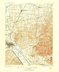
Loading map...1906 Map of Chillicothe
USGS Topo · Published 1954About this map
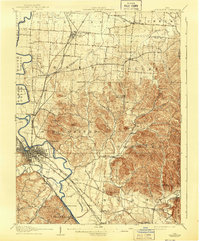
The city of Chillicothe serves as the focal point of this landscape, situated at the confluence of the Scioto River and Paint Creek. During this era, the region was a bustling hub of transportation where the Norfolk and Western and the Baltimore and Ohio RR (Southwestern Division) intersected with the Scioto Valley and New England RR. This convergence of rail lines across the fertile river valleys supported significant local settlements like Kingston and Londonderry.
Find a feature on this map
77 named features on this map. Tap any name to fly to it.
Don’t see what you’re looking for? This feature index may not catch every label — zoom into the map to look around manually.
Map Details
Date Portrayed1906
Date Published1954
PublisherU.S. Geological Survey
Map TypeTopographic
Scale1:62,500
Physical Dimensions17 x 20.7 inches
Editions of this 1906 Chillicothe Map
This is the sole edition of this map. No revisions or reprints were ever made.
Historical Maps of Chillicothe Through Time
Featured Locations
Source Details
SourceU.S. Geological Survey
CopyrightPublic Domain