1990s Maps of Jackson Township, Ohio
Explore 4 historic maps of Jackson Township from the 1990s. These maps offer a rare glimpse into what life looked like during the 1990s — showing old roads, neighborhoods, homes, and landmarks that have changed or disappeared over time.
Whether you're researching your family's past, planning a metal detecting trip, or studying how Jackson Township's landscape evolved across the 1990s, these high-resolution maps are a powerful tool for exploring the history of this region.
- Focus on a specific era: All maps on this page are from the 1990s, giving you a focused view of this time period.
- See what’s changed: Compare century-old streets, trails, and buildings to today's modern landscape using overlays and satellite layers.
- Research with precision: Use these maps for genealogy, historical research, land use analysis, or educational projects.
- View, download, or print: Maps are fully viewable online in high resolution, and can be downloaded or printed for your own records.
Start exploring Jackson Township's history through authentic maps from the 1990s. This is your window into the past.
Jackson Township, OH maps
(4)- 1994 Map of North Canton, 1997 Print
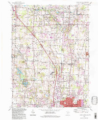 1994 North Canton1997 Print · USGSThe crossroads of the historic Western Reserve and Congress Lands are revealed in this detailed survey of the corridor between Akron and Canton in the late twentieth century. Researchers can locate ancestral sites including Greensburg Cem, Millroy Sch, and the community of Uniontown.
 - 1994 Map of Canal Fulton, 1997 Print
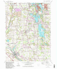 1994 Canal Fulton1997 Print · USGSStark and Summit counties meet in this 1990s survey of a historic canal and river corridor. Genealogists can trace family sites near Manchester and Canal Fulton, while collectors will find the legacy of the Ohio Canal and Penn Central rail lines.
 - 1994 Map of Massillon, 1998 Print
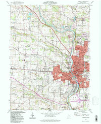 1994 Massillon1998 Print · USGSMassillon and the Tuscarawas River valley are shown here in the mid-1990s as the region's industrial roots met modern suburban growth. Genealogists and local historians can trace family-named sites like Clapper Cem or locate the sprawling Massillon State Hospital.
 - 1994 Map of Canton West, 2000 Print
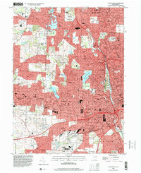 1994 Canton West2000 Print · USGSStark County’s urban core and surrounding neighborhoods are captured here in the mid-1990s as the suburbs of North Canton and Genoa expanded. Genealogists and local historians can locate family plots in Calvary Cemetery or trace landmarks like McKinley Memorial Park and Meyers Lake.
End of results
Showing maps 1-4 of 4
Top cities near Jackson Township
- Akron historical maps
- Canton historical maps
- Plain historical maps
- Massillon historical maps
- Green historical maps
- Barberton historical maps
See more
Top neighborhoods of Jackson Township
- Monterey Heights historical maps
- Oak Ridge historical maps
- Amherst Heights historical maps
- Crystal Springs historical maps
- Greenwood Acres historical maps
- Kendall Heights historical maps
See more
Frequently asked questions
- What are the different types of historical maps available for Jackson Township?
- What is the oldest map of Jackson Township?
- Where can I purchase historical maps of Jackson Township for my home or office?
- Where can I download high-res historical maps of Jackson Township?
- Are there historical topographic maps available for Jackson Township?
- Is there historical aerial imagery available for Jackson Township?
- Where are historical maps of Jackson Township sourced from?