1960s Maps of Paris Township, Ohio
Explore 5 historic maps of Paris Township from the 1960s. These maps offer a rare glimpse into what life looked like during the 1960s — showing old roads, neighborhoods, homes, and landmarks that have changed or disappeared over time.
Whether you're researching your family's past, planning a metal detecting trip, or studying how Paris Township's landscape evolved across the 1960s, these high-resolution maps are a powerful tool for exploring the history of this region.
- Focus on a specific era: All maps on this page are from the 1960s, giving you a focused view of this time period.
- See what’s changed: Compare century-old streets, trails, and buildings to today's modern landscape using overlays and satellite layers.
- Research with precision: Use these maps for genealogy, historical research, land use analysis, or educational projects.
- View, download, or print: Maps are fully viewable online in high resolution, and can be downloaded or printed for your own records.
Start exploring Paris Township's history through authentic maps from the 1960s. This is your window into the past.
Paris Township, OH maps
(5)- 1960 Map of Homeworth, 1961 Print
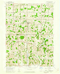 1960 Homeworth1961 Print · USGSEastern Ohio farm country and small rail towns come alive in the early sixties as the Pennsylvania railroad cuts through Homeworth. Researchers can locate family landmarks like the Fairmount Childrens Home, Walker Cemetery, and the Knox School.4 unique versions available
 - 1960 Map of Robertsville, 1961 Print
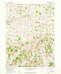 1960 Robertsville1961 Print · USGSStark County in the early 1960s was a landscape defined by its mining operations and rural rail hubs. Researchers can trace the New York Chicago and St Louis line through Robertsville or locate family sites like Beech Ch and Zwick Cem.4 unique versions available
 - 1960 Map of Minerva, 1961 Print
 1960 Minerva1961 Print · USGSMinerva and its neighboring townships in the early 1960s show a region deeply connected by the Pennsylvania and New York Central rail lines. Genealogists and local historians can trace rural family roots through landmarks like St Pauls Ch, Still Fork Ch Cem, and the historic Geographers Line.2 unique versions available
 - 1960 Map of Malvern, 1961 Print
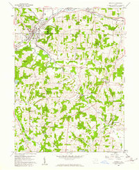
 1960 Malvern1961 Print · USGSSandy Creek and the railroad corridors of the Stark and Carroll County border define this era of Ohio industry and rural life. Genealogists can trace family roots through landmarks like Fritchleys Corners, the St Marys Ch, and the brick-making works at Malvern.4 unique versions available
 - 1962 Map of Canton
 1962 Canton1962 Print · USGSThe industrial heartland of Eastern Ohio and Western Pennsylvania thrives in the early sixties as steel mills and rail lines dominate the river valleys. Genealogists and historians can trace local landmarks like McKinley National Memorial, Malone College, and industrial sites such as Republic Steel Corp.2 unique versions available
End of results
Showing maps 1-5 of 5
Top cities near Paris Township
- Canton historical maps
- Plain historical maps
- Alliance historical maps
- North Canton historical maps
- Louisville historical maps
- Paris historical maps
See more
Top neighborhoods of Paris Township
Frequently asked questions
- What are the different types of historical maps available for Paris Township?
- What is the oldest map of Paris Township?
- Where can I purchase historical maps of Paris Township for my home or office?
- Where can I download high-res historical maps of Paris Township?
- Are there historical topographic maps available for Paris Township?
- Is there historical aerial imagery available for Paris Township?
- Where are historical maps of Paris Township sourced from?