1950s Maps of Richfield, Ohio
Explore 6 historic maps of Richfield from the 1950s. These maps offer a rare glimpse into what life looked like during the 1950s — showing old roads, neighborhoods, homes, and landmarks that have changed or disappeared over time.
Whether you're researching your family's past, planning a metal detecting trip, or studying how Richfield's landscape evolved across the 1950s, these high-resolution maps are a powerful tool for exploring the history of this region.
- Focus on a specific era: All maps on this page are from the 1950s, giving you a focused view of this time period.
- See what’s changed: Compare century-old streets, trails, and buildings to today's modern landscape using overlays and satellite layers.
- Research with precision: Use these maps for genealogy, historical research, land use analysis, or educational projects.
- View, download, or print: Maps are fully viewable online in high resolution, and can be downloaded or printed for your own records.
Start exploring Richfield's history through authentic maps from the 1950s. This is your window into the past.
Richfield, OH maps
(6)- 1950 Map of Cleveland
 1950 Cleveland1950 Print · USGSCovers Richfield, including Cleveland, Akron, and other nearby areas
 - 1953 Map of Broadview Heights, 1955 Print
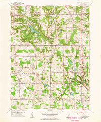
 1953 Broadview Heights1955 Print · USGSBroadview Heights and the southern Cleveland suburbs appear in the early fifties during a period of major infrastructure expansion. Genealogists and local historians can locate early broadcast sites like Television Station (WXEL), local schools including Marycrest Sch, and the emerging path of the Ohio Turnpike.2 unique versions available
 - 1953 Map of Northfield, 1955 Print
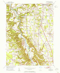 1953 Northfield1955 Print · USGSThe Cuyahoga Valley in the early 1950s reveals a landscape poised between its industrial rail past and the coming highway era. Genealogists and researchers can trace the early path of the Ohio Turnpike, the mill site at Jaite, and mid-century landmarks like the Drive-in Theater.2 unique versions available
 - 1953 Map of West Richfield, 1955 Print
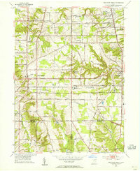
 1953 West Richfield1955 Print · USGSMedina and Summit counties show a landscape of transition in the early fifties as historic rural townships began to grow. Genealogists and local historians can trace family locations near Morris Chapel, Hinckley Lake, and old burial grounds like Beach Cem.
 - 1953 Map of Peninsula, 1955 Print
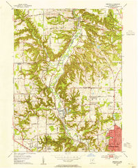 1953 Peninsula1955 Print · USGSSummit County in the early fifties showcases a river valley caught between its industrial heritage and burgeoning parklands. You can trace the historic Ohio and Erie Canal past settlements like Everett and Botzum, or locate local landmarks like East Bath Cem and Camp Manatoc.
 - 1956 Map of Cleveland, 1967 Print
 1956 Cleveland1967 Print · USGSNortheast Ohio and Western Pennsylvania are shown at their industrial height during the mid-fifties, from the steel mills to the lakeshore. Researchers can trace the massive Ravenna Arsenal, the Ohio Turnpike, and vanished rail sidings of the B & O RR.3 unique versions available
End of results
Showing maps 1-6 of 6
Top cities near Richfield
- Cleveland historical maps
- Akron historical maps
- Parma historical maps
- Cuyahoga Falls historical maps
- Lakewood historical maps
- Strongsville historical maps
See more
Top neighborhoods of Richfield
- West Richfield historical maps
- West Center historical maps
- East Center historical maps
- Richfield Heights historical maps
Frequently asked questions
- What are the different types of historical maps available for Richfield?
- What is the oldest map of Richfield?
- Where can I purchase historical maps of Richfield for my home or office?
- Where can I download high-res historical maps of Richfield?
- Are there historical topographic maps available for Richfield?
- Is there historical aerial imagery available for Richfield?
- Where are historical maps of Richfield sourced from?