1990s Maps of Braceville Township, Ohio
Explore 5 historic maps of Braceville Township from the 1990s. These maps offer a rare glimpse into what life looked like during the 1990s — showing old roads, neighborhoods, homes, and landmarks that have changed or disappeared over time.
Whether you're researching your family's past, planning a metal detecting trip, or studying how Braceville Township's landscape evolved across the 1990s, these high-resolution maps are a powerful tool for exploring the history of this region.
- Focus on a specific era: All maps on this page are from the 1990s, giving you a focused view of this time period.
- See what’s changed: Compare century-old streets, trails, and buildings to today's modern landscape using overlays and satellite layers.
- Research with precision: Use these maps for genealogy, historical research, land use analysis, or educational projects.
- View, download, or print: Maps are fully viewable online in high resolution, and can be downloaded or printed for your own records.
Start exploring Braceville Township's history through authentic maps from the 1990s. This is your window into the past.
Braceville Township, OH maps
(5)- 1994 Map of Cleveland South
 1994 Cleveland South1994 Print · USGSThe metropolitan corridor between Akron and Cleveland is shown here in the mid-nineties during a period of significant suburban growth. Researchers can trace the path of the Ohio Turnpike or explore expansive recreation lands like West Branch State Park.
 - 1994 Map of Southington, 1997 Print
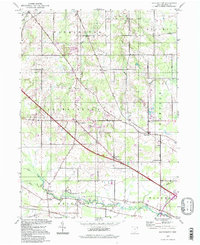 1994 Southington1997 Print · USGSTrumbull County in the mid-1990s reflects a rural landscape shaped by the headwaters of the Mahoning River. Genealogists and historians can trace local settlements like Southington and Delightful, or locate the Warren Airfield and Reform Cem.
 - 1994 Map of Newton Falls, 1997 Print
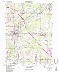 1994 Newton Falls1997 Print · USGSNewton Falls and the Mahoning River valley appear here in the late twentieth century, showing a mix of industrial corridors and small settlements. Trace the rail lines of the Conrail or locate local landmarks like Phalanx Station, Pricetown, and the St Michaels Cem.
 - 1994 Map of Garrettsville, 1997 Print
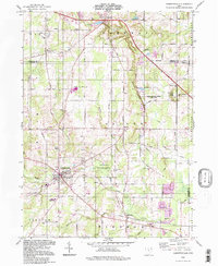 1994 Garrettsville1997 Print · USGSGarrettsville and the surrounding townships of Portage and Geauga counties are captured here in the late twentieth century. Genealogists and local historians can trace family-named sites like Abbot Cem and Harrington Cem or explore the distinct geology of Nelson Ledge.
 - 1994 Map of Windham, 1997 Print
 1994 Windham1997 Print · USGSPortage and Trumbull counties are shown in the 1990s as a landscape shaped by military infrastructure and rural rail-and-river networks. Researchers can trace the massive Ravenna Arsenal, find old burial sites like St Josephs Cem, and locate the waters of Kirwan Reservoir.
End of results
Showing maps 1-5 of 5
Top cities near Braceville Township
- Warren historical maps
- Austintown historical maps
- Weathersfield Township historical maps
- Howland Township historical maps
- Niles historical maps
- Champion Township historical maps
See more
Top neighborhoods of Braceville Township
- Phalanx historical maps
- Shihold historical maps
- Center of the World historical maps
- Braceville historical maps
Frequently asked questions
- What are the different types of historical maps available for Braceville Township?
- What is the oldest map of Braceville Township?
- Where can I purchase historical maps of Braceville Township for my home or office?
- Where can I download high-res historical maps of Braceville Township?
- Are there historical topographic maps available for Braceville Township?
- Is there historical aerial imagery available for Braceville Township?
- Where are historical maps of Braceville Township sourced from?