1950s Maps of Warren, Ohio
Explore 6 historic maps of Warren from the 1950s. These maps offer a rare glimpse into what life looked like during the 1950s — showing old roads, neighborhoods, homes, and landmarks that have changed or disappeared over time.
Whether you're researching your family's past, planning a metal detecting trip, or studying how Warren's landscape evolved across the 1950s, these high-resolution maps are a powerful tool for exploring the history of this region.
- Focus on a specific era: All maps on this page are from the 1950s, giving you a focused view of this time period.
- See what’s changed: Compare century-old streets, trails, and buildings to today's modern landscape using overlays and satellite layers.
- Research with precision: Use these maps for genealogy, historical research, land use analysis, or educational projects.
- View, download, or print: Maps are fully viewable online in high resolution, and can be downloaded or printed for your own records.
Start exploring Warren's history through authentic maps from the 1950s. This is your window into the past.
Warren, OH maps
(6)- 1950 Map of Cleveland
 1950 Cleveland1950 Print · USGSCovers Warren, including Cleveland, Akron, and other nearby areas
 - 1952 Map of Southington, 1954 Print
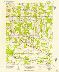 1952 Southington1954 Print · USGSTrumbull County in the early fifties shows a landscape of traditional township grids and strategic rail corridors. Genealogists and local historians can trace family locations near Southington, the Reform Cem, and the river community of Phalanx.3 unique versions available
 - 1954 Map of Girard, 1956 Print
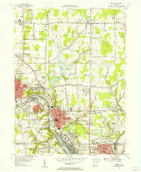 1954 Girard1956 Print · USGSThe Mahoning River valley in the mid-1950s shows an industrial powerhouse at its peak, dominated by a dense rail network. Genealogists and local historians can trace family locations near Girard and McDonald, or locate sites like St Rose Sch and Tod Homestead Cemetery.
 - 1956 Map of Cleveland, 1967 Print
 1956 Cleveland1967 Print · USGSNortheast Ohio and Western Pennsylvania are shown at their industrial height during the mid-fifties, from the steel mills to the lakeshore. Researchers can trace the massive Ravenna Arsenal, the Ohio Turnpike, and vanished rail sidings of the B & O RR.3 unique versions available
 - 1959 Map of Newton Falls, 1961 Print
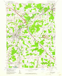 1959 Newton Falls1961 Print · USGSTrumbull and Mahoning counties at the end of the fifties show a landscape of heavy industry and military installations. Genealogists can trace family names at St Michaels Cem or explore rail-era settlements like Phalanx Station and Leavittsburg.4 unique versions available
 - 1959 Map of Warren, 1961 Print
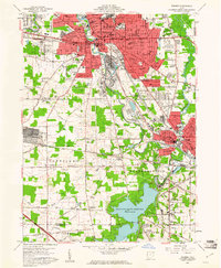 1959 Warren1961 Print · USGSWarren and Niles are at the heart of the Mahoning Valley's industrial peak in the late fifties. Genealogists and historians can trace neighborhood growth through dozens of named sites like Oakwood Cemetery, Harding High Sch, and the DeForest Junction rail yards.4 unique versions available
End of results
Showing maps 1-6 of 6
Top cities near Warren
- Youngstown historical maps
- Boardman historical maps
- Austintown historical maps
- Weathersfield Township historical maps
- Howland Township historical maps
- Niles historical maps
See more
Top neighborhoods of Warren
- Belvedere Park historical maps
- Northwest Warren historical maps
- Oak Knoll historical maps
- Perkinswood historical maps
- Southwest Warren historical maps
- North End historical maps
See more
Frequently asked questions
- What are the different types of historical maps available for Warren?
- What is the oldest map of Warren?
- Where can I purchase historical maps of Warren for my home or office?
- Where can I download high-res historical maps of Warren?
- Are there historical topographic maps available for Warren?
- Is there historical aerial imagery available for Warren?
- Where are historical maps of Warren sourced from?