1910s Maps of Tuscarawas County, Ohio
Explore 7 historic maps of Tuscarawas County from the 1910s. These maps offer a rare glimpse into what life looked like during the 1910s — showing old roads, neighborhoods, homes, and landmarks that have changed or disappeared over time.
Whether you're researching your family's past, planning a metal detecting trip, or studying how Tuscarawas County's landscape evolved across the 1910s, these high-resolution maps are a powerful tool for exploring the history of this region.
- Focus on a specific era: All maps on this page are from the 1910s, giving you a focused view of this time period.
- See what’s changed: Compare century-old streets, trails, and buildings to today's modern landscape using overlays and satellite layers.
- Research with precision: Use these maps for genealogy, historical research, land use analysis, or educational projects.
- View, download, or print: Maps are fully viewable online in high resolution, and can be downloaded or printed for your own records.
Start exploring Tuscarawas County's history through authentic maps from the 1910s. This is your window into the past.
Tuscarawas County, OH maps
(7)- 1911 Map of Antrim
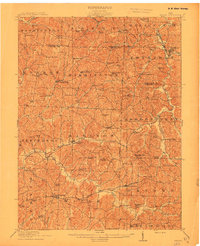 1911 Antrim1911 Print · USGSGuernsey County and parts of Harrison and Tuscarawas Counties appear here just after the first decade of the century, when the rural landscape was dotted with family-named schools and crossroads. Genealogists can trace the exact locations of vanished local landmarks like Moccasin School, Wesley Church, and the dual-named Winterset P.O. Winchester.3 unique versions available
 - 1911 Map of Uhrichsville, 1937 Print
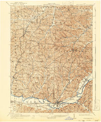
 1911 Uhrichsville1937 Print · USGSTuscarawas County's industrial river valleys and canal routes are shown here at their height before the mid-century decline of rail. Researchers can trace the path of the Ohio and Erie Canal and locate family-named landmarks like Beidler P O, Wesley Church, and Gnadenhutten.
 - 1911 Map of Newcomerstown, 1959 Print
 1911 Newcomerstown1959 Print · USGSTuscarawas County in the early twentieth century is captured here as a corridor of heavy rail and old canal routes. Genealogists can locate family-named rural schools like Steitz School or May School and trace the original path of the Ohio Canal near Port Washington.
 - 1912 Map of Dover, 1939 Print
 1912 Dover1939 Print · USGSTuscarawas and Stark Counties are shown in the early twentieth century as coal and rail corridors shaped the valley floors. Researchers can locate unique landmarks like the Octagonal School, the historic Zoar community, and the path of the Ohio Treaty Line.2 unique versions available
 - 1912 Map of Cambridge, 1946 Print
 1912 Cambridge1946 Print · USGSGuernsey County was a bustling hub of rail and river commerce at the start of the century. You can trace the path of the National Road and locate family landmarks like Barnes Mill, Zion Church, and dozens of district schools.2 unique versions available
 - 1913 Map of Newcomerstown, 1943 Print
 1913 Newcomerstown1943 Print · USGSTuscarawas County's industrial and educational roots are on display in the years before the Great War. Genealogists and historians can trace the Pennsylvania and Ohio Canal, locate the West Lafayette College, and find family schoolhouses like Putt School and Steitz School.
 - 1914 Map of Navarre, 1940 Print
 1914 Navarre1940 Print · USGSNortheast Ohio’s industrial and rural landscape is shown here as the coal and rail era reached its peak. Genealogists can trace family roots through dozens of local schools like Frogpond School and follow the angled path of the historic Military Treaty Line.2 unique versions available
End of results
Showing maps 1-7 of 7
Top cities of Tuscarawas County
- New Philadelphia historical maps
- Dover historical maps
- Uhrichsville historical maps
- Goshen historical maps
- Newcomerstown historical maps
- Dennison historical maps
See more
Frequently asked questions
- What are the different types of historical maps available for Tuscarawas County?
- What is the oldest map of Tuscarawas County?
- Where can I purchase historical maps of Tuscarawas County for my home or office?
- Where can I download high-res historical maps of Tuscarawas County?
- Are there historical topographic maps available for Tuscarawas County?
- Is there historical aerial imagery available for Tuscarawas County?
- Where are historical maps of Tuscarawas County sourced from?