1990s Maps of Tuscarawas County, Ohio
Explore 27 historic maps of Tuscarawas County from the 1990s. These maps offer a rare glimpse into what life looked like during the 1990s — showing old roads, neighborhoods, homes, and landmarks that have changed or disappeared over time.
Whether you're researching your family's past, planning a metal detecting trip, or studying how Tuscarawas County's landscape evolved across the 1990s, these high-resolution maps are a powerful tool for exploring the history of this region.
- Focus on a specific era: All maps on this page are from the 1990s, giving you a focused view of this time period.
- See what’s changed: Compare century-old streets, trails, and buildings to today's modern landscape using overlays and satellite layers.
- Research with precision: Use these maps for genealogy, historical research, land use analysis, or educational projects.
- View, download, or print: Maps are fully viewable online in high resolution, and can be downloaded or printed for your own records.
Start exploring Tuscarawas County's history through authentic maps from the 1990s. This is your window into the past.
Tuscarawas County, OH maps
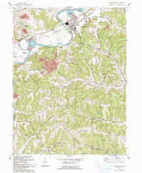
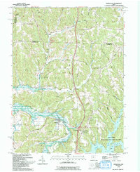
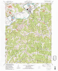
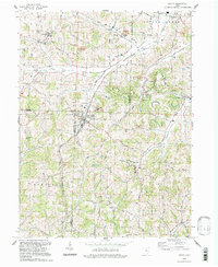
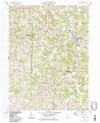
(27)- 1993 Map of Uhrichsville
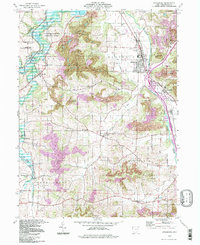
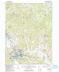 1993 Uhrichsville1993 Print · USGSUhrichsville and Dennison are captured in the early nineties, showing a landscape shaped by the rail and clay industries. Genealogists can trace family sites at Roswell Cem, St Marys Ch, and along the banks of Stillwater Creek.
 - 1993 Map of Fresno
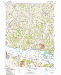 1993 Fresno1993 Print · USGSCentral Ohio at the start of the 1990s reveals a landscape defined by the Tuscarawas River and winding ridges. Genealogists can trace numerous family-named burial sites including Waggoner Cem, Clappboard Cem, and Kimble Cem.
 - 1993 Map of Newcomerstown
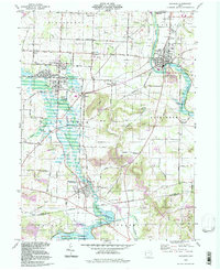
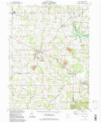
 1993 Newcomerstown1993 Print · USGSThe Tuscarawas River valley in the early nineties shows a landscape deeply tied to its industrial and athletic heritage. Genealogists can trace family footprints across Stark Patent lands and find local landmarks like Cy Young Memorial Park and the Centenary Cem.
 - 1993 Map of Baltic
 1993 Baltic1993 Print · USGSThe hills of Tuscarawas and Holmes counties come alive in this early 1990s record of a landscape defined by farming and mining. Researchers can locate family landmarks like West Lawn Cem, Meadow Valley Sch, and the quiet crossroads of Fiat.
 - 1993 Map of Gnadenhutten
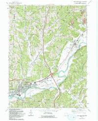
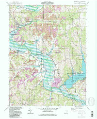
 1993 Gnadenhutten1993 Print · USGSGnadenhutten and the Tuscarawas River valley are shown in the early nineties as a blend of historic canal-era sites and modern industry. Researchers can trace family sites at Lock Seventeen Cem, locate the Indian Valley High Sch, or explore the extensive Oil Field and Gnadenhutten Historical Park.
 - 1993 Map of Tippecanoe
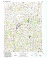
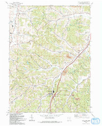
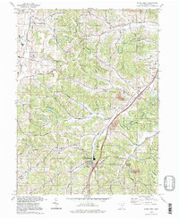
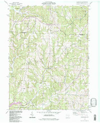
 1993 Tippecanoe1993 Print · USGSHarrison and Tuscarawas counties appear in the early nineties as a landscape of winding creek valleys and coal-country history. Researchers can trace family sites like Mays School and Rush Cem or follow the path of an old railroad grade through Stillwater.
 - 1993 Map of Stone Creek
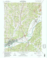
 1993 Stone Creek1993 Print · USGSTuscarawas County's rural valleys are captured here in the early 1990s as modern highways began to parallel older transport routes. You can trace family lands and community centers from Stone Creek to Yorktown, including St Johns Ch (Luth) and the Old RR Grade.
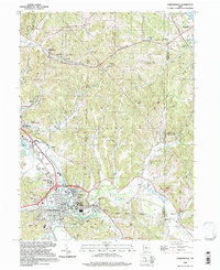
 - 1993 Map of New Philadephia, 1994 Print
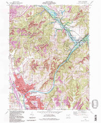
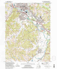
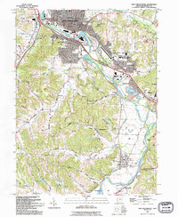 1993 New Philadephia1994 Print · USGSTuscarawas County in the early nineties shows a transition from coal and canal history to a modern educational and retail hub. Trace the Ohio Canal (Abandoned) near Tuscarawas or locate the St Peters Ch and Mud Run Cem.
 - 1994 Map of Kimbolton
 1994 Kimbolton1994 Print · USGSThe Guernsey County countryside at the close of the twentieth century shows a landscape transitioning between rural heritage and public recreation. Genealogists can trace family landmarks at Jones Cem, Kimbolton Cem, and the old Liberty Sch.2 unique versions available
 - 1994 Map of Fresno, 1998 Print
 1994 Fresno1998 Print · USGSCoshocton County in the mid-1990s reveals a landscape of industrial strip mining and deep-rooted rural settlements along the Tuscarawas River. Genealogists can trace family names at numerous burial sites like Kimble Cem, Fairview Cem, and Woods College Cem.
 - 1994 Map of Mineral City, 1998 Print
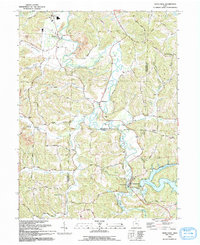
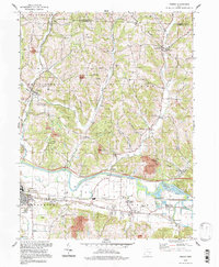
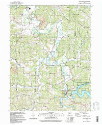
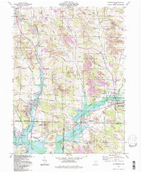
 1994 Mineral City1998 Print · USGSIn the mid-1990s, the Tuscarawas and Carroll County line was a landscape defined by industry and water. Local historians can trace the United States Railroad through Mineral City or find rural landmarks like St Matthews Ch and Atwood Lake Park.
 - 1994 Map of Tippecanoe, 1998 Print
 1994 Tippecanoe1998 Print · USGSThe borderlands of Tuscarawas and Harrison Counties come into focus in the 1990s as a landscape of managed watersheds and coal heritage. Trace old family connections at Dutch Valley Cem, Rush Church, or along the Old Railroad Grade.
 - 1994 Map of Dover, 1998 Print
 1994 Dover1998 Print · USGSThe Tuscarawas River valley in the late twentieth century shows the continued growth of Dover and New Philadelphia alongside historic water routes. Genealogists and local historians can trace landmarks like Maple Grove Grove Cem, Unity Grange, and the remains of the Abandoned Canal.
 - 1994 Map of Gnadenhutten, 1998 Print
 1994 Gnadenhutten1998 Print · USGSGnadenhutten and the Tuscarawas River valley are captured in the mid-nineties, showing a landscape shaped by both early history and modern industry. Researchers can trace the CONRAIL tracks or locate family landmarks like Crossroads Cem, Lock Seventeen, and Indian Valley High Sch.
 - 1994 Map of Newcomerstown, 1998 Print
 1994 Newcomerstown1998 Print · USGSTuscarawas County in the 1990s shows a landscape where historic river-bottom settlements meet modern transit corridors. Genealogists and historians can trace family landmarks like Mt Zion Cem, the STARK PATENT boundaries, and the Cy Young Memorial Park.
 - 1994 Map of Navarre, 1998 Print
 1994 Navarre1998 Print · USGSNavarre and Beach City are captured in the 1990s as the local landscape transitioned from its mining and railroading roots. Researchers can trace family history through numerous rural burial sites like Slutz Cem and Bose Cem or locate the historic Treaty Line.
 - 1994 Map of Strasburg, 1998 Print
 1994 Strasburg1998 Print · USGSTuscarawas County's industrial and rural character is on full display in the 1990s as the W & L E railroad moves through the village of Strasburg. Researchers can trace old family burial grounds like Garber Cem and Dundee Cem alongside the heavy footprint of local Strip Mine operations.
 - 1994 Map of Wilmot, 1998 Print
 1994 Wilmot1998 Print · USGSThe rural crossroads of Wayne, Stark, and Holmes counties are captured here in the late twentieth century. Genealogists and local historians can trace family-named sites like Hershberger Cem, Beidler Sch, and the settlements of Mount Eaton and Wilmot.
 - 1994 Map of New Philadephia, 1998 Print
 1994 New Philadephia1998 Print · USGSThe Tuscarawas Valley in the mid-nineties shows a landscape where industrial heritage meets academic growth and historic preservation. Genealogists can locate family sites near St Peters Ch, Fair St Cem, and old settlements like Wainwright and Midvale.
 - 1994 Map of Stone Creek, 1998 Print
 1994 Stone Creek1998 Print · USGSTuscarawas County in the 1990s remains a landscape of deep valleys and hilltop homesteads. Genealogists can trace family names through landmarks like Dietz Cem and historic rural congregations at St Johns Ch and Jerusalem Ch.
 - 1994 Map of Baltic, 1998 Print
 1994 Baltic1998 Print · USGSThe tri-county border area of Holmes, Tuscarawas, and Coshocton comes into focus in the 1990s, centering on the village of Baltic. Researchers can trace rural landmarks from West Lawn Cem to the local Buckeye Sch and industrial sites like the nearby Claypit.
 - 1994 Map of Uhrichsville, 1998 Print
 1994 Uhrichsville1998 Print · USGSThe twin cities of Uhrichsville and Dennison anchor this 1990s study of the Tuscarawas County coal and clay country. Trace the footprints of local industry and faith at the Roanoke Kilns, the Strip Mine, and St Elizabeth Ch.
 - 1994 Map of Birmingham, 1998 Print
 1994 Birmingham1998 Print · USGSThe hills of Guernsey and Tuscarawas counties are captured here in the late twentieth century, showing a landscape of small crossroads and creek valleys. Genealogists can locate family landmarks like Cumberland Cem, Wesley Ch, and the old Salem-Washington Sch.
 - 1994 Map of Waynesburg, 1998 Print
 1994 Waynesburg1998 Print · USGSThe tri-county border area of Stark, Tuscarawas, and Carroll counties comes into focus in the 1990s as a hub of surface mining and rail transit. Researchers can trace the layout of Waynesburg and Magnolia alongside landmarks like Evergreen Cemetery and the Conrail line.
 - 1994 Map of Freeport, 1998 Print
 1994 Freeport1998 Print · USGSThe hill country where Harrison and Guernsey Counties meet is captured here in the 1990s, centered on the historic village of Freeport. Genealogists can trace family landmarks like the Scotch Covenanter Cem, Chestnut Hill Ch, and Londonderry Sch.
Showing maps 1-25 of 27
Top cities of Tuscarawas County
- New Philadelphia historical maps
- Dover historical maps
- Uhrichsville historical maps
- Goshen historical maps
- Newcomerstown historical maps
- Dennison historical maps
See more
Frequently asked questions
- What are the different types of historical maps available for Tuscarawas County?
- What is the oldest map of Tuscarawas County?
- Where can I purchase historical maps of Tuscarawas County for my home or office?
- Where can I download high-res historical maps of Tuscarawas County?
- Are there historical topographic maps available for Tuscarawas County?
- Is there historical aerial imagery available for Tuscarawas County?
- Where are historical maps of Tuscarawas County sourced from?