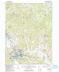
1993 Map of Uhrichsville
USGS Topo · Published 1993About this map
The industrial and transportation history of the Uhrichsville and Dennison twin cities is defined by the winding course of Stillwater Creek. This 1993 revision, based on surveys dating back to the 1960s, documents the dense residential grids of these communities alongside the legacy of the local clay and rail industries, evidenced by several Kilns and an Old Railroad Grade cutting through the terrain. To the north and east, the landscape transitions into the hills of Union and Warren townships, where smaller settlements like Roswell and Barnhill appear amidst numerous Oil Wells. Genealogical interest is high throughout the quadrangle, with numerous rural landmarks such as St Elizabeth Ch, Calvary Cem, and the Prosperity Grange serving as anchors for the outlying farming and mining communities across the Tuscarawas and Carroll county line.
Find a feature on this map
64 named features on this map. Tap any name to fly to it.
Don’t see what you’re looking for? This feature index may not catch every label — zoom into the map to look around manually.
Map Details
Editions of this 1993 Uhrichsville Map
This is the sole edition of this map. No revisions or reprints were ever made.
Other maps of this area

1902 · Scio
USGS Topo · 1:62,500

1904 · Scio
USGS Topo · 1:62,500

1909 · Uhrichsville
USGS Topo · 1:62,500

1910 · Carrollton
USGS Topo · 1:62,500

1911 · Uhrichsville
USGS Topo · 1:62,500

1912 · Dover
USGS Topo · 1:62,500

1912 · Carrollton
USGS Topo · 1:62,500

1944 · Dover
USGS Topo · 1:62,500

1951 · Canton
USGS Topo · 1:250,000

1953 · Canton
USGS Topo · 1:250,000