
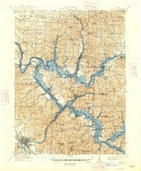
1912 Map of Dover
USGS Topo · Published 1939About this map
Tuscarawas River valley industry and settlement are frozen in time on this survey, documenting the early 20th-century landscape of northern Tuscarawas County. The map captures the complex interaction between water and rail, featuring the East Lake Erie and Ohio River Canal and the Pennsylvania System as they converge near Zoar. Historically significant boundaries, such as the Ohio Treaty Line and the North Boundary of the U S Military Land, underscore the area's colonial and frontier heritage. The upland areas are dense with rural institutions, including the Octagonal School and Zion Chapel School, providing a detailed look at the social fabric before school consolidation. From the industrial hub of Mineral City to the smaller crossroads of Somerdale and Johnston, the map illustrates a region defined by its narrow valley floors and the extraction economy of Huff Run and Conotton Creek.
Find a feature on this map
94 named features on this map. Tap any name to fly to it.
Don’t see what you’re looking for? This feature index may not catch every label — zoom into the map to look around manually.
Map Details
Editions of this 1912 Dover Map
2 editions found
Other maps of this area

1901 · Massillon
USGS Topo · 1:62,500

1901 · Canton
USGS Topo · 1:62,500

1902 · Scio
USGS Topo · 1:62,500

1903 · Massillon
USGS Topo · 1:62,500

1903 · Canton
USGS Topo · 1:62,500

1904 · Scio
USGS Topo · 1:62,500

1909 · Alliance
USGS Topo · 1:62,500

1909 · Uhrichsville
USGS Topo · 1:62,500

1910 · Carrollton
USGS Topo · 1:62,500

1911 · Uhrichsville
USGS Topo · 1:62,500