1990s Maps of Sugarcreek, Ohio
Explore 4 historic maps of Sugarcreek from the 1990s. These maps offer a rare glimpse into what life looked like during the 1990s — showing old roads, neighborhoods, homes, and landmarks that have changed or disappeared over time.
Whether you're researching your family's past, planning a metal detecting trip, or studying how Sugarcreek's landscape evolved across the 1990s, these high-resolution maps are a powerful tool for exploring the history of this region.
- Focus on a specific era: All maps on this page are from the 1990s, giving you a focused view of this time period.
- See what’s changed: Compare century-old streets, trails, and buildings to today's modern landscape using overlays and satellite layers.
- Research with precision: Use these maps for genealogy, historical research, land use analysis, or educational projects.
- View, download, or print: Maps are fully viewable online in high resolution, and can be downloaded or printed for your own records.
Start exploring Sugarcreek's history through authentic maps from the 1990s. This is your window into the past.
Sugarcreek, OH maps
(4)- 1993 Map of Baltic
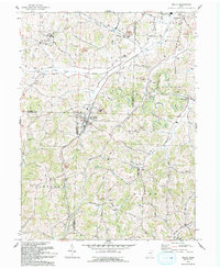 1993 Baltic1993 Print · USGSThe hills of Tuscarawas and Holmes counties come alive in this early 1990s record of a landscape defined by farming and mining. Researchers can locate family landmarks like West Lawn Cem, Meadow Valley Sch, and the quiet crossroads of Fiat.
 - 1994 Map of Strasburg, 1998 Print
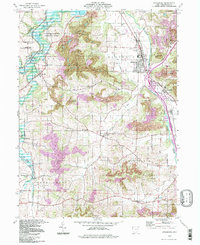 1994 Strasburg1998 Print · USGSTuscarawas County's industrial and rural character is on full display in the 1990s as the W & L E railroad moves through the village of Strasburg. Researchers can trace old family burial grounds like Garber Cem and Dundee Cem alongside the heavy footprint of local Strip Mine operations.
 - 1994 Map of Baltic, 1998 Print
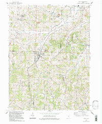 1994 Baltic1998 Print · USGSThe tri-county border area of Holmes, Tuscarawas, and Coshocton comes into focus in the 1990s, centering on the village of Baltic. Researchers can trace rural landmarks from West Lawn Cem to the local Buckeye Sch and industrial sites like the nearby Claypit.
 - 1994 Map of Sugarcreek, 1998 Print
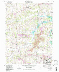 1994 Sugarcreek1998 Print · USGSTuscarawas and Holmes County settlements are shown here in the 1990s, where the historic Greenville Treaty Line still defines local land boundaries. Researchers can trace family roots through numerous sites like Hardscrabble Cem, Shanesville, and Winesburg.
End of results
Showing maps 1-4 of 4
Top cities near Sugarcreek
- Massillon historical maps
- New Philadelphia historical maps
- Dover historical maps
- Coshocton historical maps
- Berlin historical maps
- Newcomerstown historical maps
See more
Top neighborhoods of Sugarcreek
Frequently asked questions
- What are the different types of historical maps available for Sugarcreek?
- What is the oldest map of Sugarcreek?
- Where can I purchase historical maps of Sugarcreek for my home or office?
- Where can I download high-res historical maps of Sugarcreek?
- Are there historical topographic maps available for Sugarcreek?
- Is there historical aerial imagery available for Sugarcreek?
- Where are historical maps of Sugarcreek sourced from?