1990s Maps of Yorktown, Ohio
Explore 2 historic maps of Yorktown from the 1990s. These maps offer a rare glimpse into what life looked like during the 1990s — showing old roads, neighborhoods, homes, and landmarks that have changed or disappeared over time.
Whether you're researching your family's past, planning a metal detecting trip, or studying how Yorktown's landscape evolved across the 1990s, these high-resolution maps are a powerful tool for exploring the history of this region.
- Focus on a specific era: All maps on this page are from the 1990s, giving you a focused view of this time period.
- See what’s changed: Compare century-old streets, trails, and buildings to today's modern landscape using overlays and satellite layers.
- Research with precision: Use these maps for genealogy, historical research, land use analysis, or educational projects.
- View, download, or print: Maps are fully viewable online in high resolution, and can be downloaded or printed for your own records.
Start exploring Yorktown's history through authentic maps from the 1990s. This is your window into the past.
Yorktown, OH maps
(2)- 1993 Map of Stone Creek
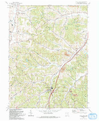 1993 Stone Creek1993 Print · USGSTuscarawas County's rural valleys are captured here in the early 1990s as modern highways began to parallel older transport routes. You can trace family lands and community centers from Stone Creek to Yorktown, including St Johns Ch (Luth) and the Old RR Grade.
 - 1994 Map of Stone Creek, 1998 Print
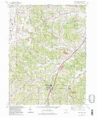 1994 Stone Creek1998 Print · USGSTuscarawas County in the 1990s remains a landscape of deep valleys and hilltop homesteads. Genealogists can trace family names through landmarks like Dietz Cem and historic rural congregations at St Johns Ch and Jerusalem Ch.
End of results
Showing maps 1-2 of 2
Top cities near Yorktown
- New Philadelphia historical maps
- Dover historical maps
- Uhrichsville historical maps
- Goshen historical maps
- Newcomerstown historical maps
- Walnut Creek historical maps
See more
Frequently asked questions
- What are the different types of historical maps available for Yorktown?
- What is the oldest map of Yorktown?
- Where can I purchase historical maps of Yorktown for my home or office?
- Where can I download high-res historical maps of Yorktown?
- Are there historical topographic maps available for Yorktown?
- Is there historical aerial imagery available for Yorktown?
- Where are historical maps of Yorktown sourced from?