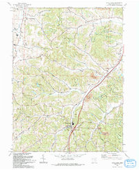
1993 Map of Stone Creek
USGS Topo · Published 1993About this map
Stone Creek serves as a central hub in this Tuscarawas County landscape, situated at the confluence of several rural valleys. The area is defined by its deep agricultural and religious roots, evidenced by congregations at St Johns Ch (Luth), St Jacobs Ch, and Crooked Run Ch. The map records a transition from traditional rail transport to modern infrastructure, where an Old RR Grade runs parallel to the newer interstate corridor, passing through the hamlet of Blackband.
Find a feature on this map
55 named features on this map. Tap any name to fly to it.
Don’t see what you’re looking for? This feature index may not catch every label — zoom into the map to look around manually.
Map Details
Editions of this 1993 Stone Creek Map
This is the sole edition of this map. No revisions or reprints were ever made.
Other maps of this area

1909 · Uhrichsville
USGS Topo · 1:62,500

1911 · Uhrichsville
USGS Topo · 1:62,500

1911 · Newcomerstown
USGS Topo · 1:62,500

1912 · Dover
USGS Topo · 1:62,500

1913 · Newcomerstown
USGS Topo · 1:62,500

1914 · Navarre
USGS Topo · 1:62,500

1943 · Newcomerstown
USGS Topo · 1:62,500

1944 · Navarre
USGS Topo · 1:62,500

1944 · Dover
USGS Topo · 1:62,500

1951 · Canton
USGS Topo · 1:250,000