1960s Maps of Van Wert County, Ohio
Explore 14 historic maps of Van Wert County from the 1960s. These maps offer a rare glimpse into what life looked like during the 1960s — showing old roads, neighborhoods, homes, and landmarks that have changed or disappeared over time.
Whether you're researching your family's past, planning a metal detecting trip, or studying how Van Wert County's landscape evolved across the 1960s, these high-resolution maps are a powerful tool for exploring the history of this region.
- Focus on a specific era: All maps on this page are from the 1960s, giving you a focused view of this time period.
- See what’s changed: Compare century-old streets, trails, and buildings to today's modern landscape using overlays and satellite layers.
- Research with precision: Use these maps for genealogy, historical research, land use analysis, or educational projects.
- View, download, or print: Maps are fully viewable online in high resolution, and can be downloaded or printed for your own records.
Start exploring Van Wert County's history through authentic maps from the 1960s. This is your window into the past.
Van Wert County, OH maps
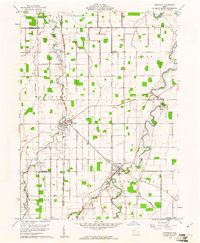
(14)- 1960 Map of Convoy, 1961 Print
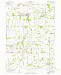
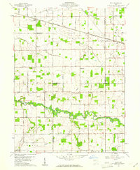
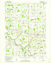
 1960 Convoy1961 Print · USGSSurrounding the rail hub of Convoy in the early 1960s, this area of Van Wert County is a landscape of established family farms and country churches. Researchers can locate the Convoy Union Jr High Sch, find Union Quarries, and trace family roots at St Johns Cem.3 unique versions available
 - 1960 Map of Ottoville, 1961 Print
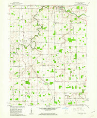
 1960 Ottoville1961 Print · USGSNorthwestern Ohio's agricultural landscape is seen here in the early sixties, defined by the winding Auglaize River and the old canal route. Genealogists can trace family landmarks and burial sites like St Marys Cem, Antioch Ch, and the hamlet of Muntanna.2 unique versions available
 - 1960 Map of Dixon, 1961 Print
 1960 Dixon1961 Print · USGSThe Indiana-Ohio borderlands come into focus in the early sixties, showing a landscape shaped by rural townships and the CONRAIL railroad. Local historians can trace family roots at Odd Fellows Cem and Alpha Cem or locate old community centers like Mentzer Ch.5 unique versions available
 - 1960 Map of Delphos, 1961 Print
 1960 Delphos1961 Print · USGSDelphos and the surrounding farm townships of Allen and Van Wert counties are captured here at the start of the 1960s. Researchers can trace the legacy of the Miami and Erie Canal (Abandoned) alongside active rail lines and rural landmarks like Morris Chapel and Landeck.3 unique versions available
 - 1960 Map of Scott, 1961 Print
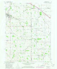
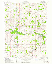
 1960 Scott1961 Print · USGSNorthwestern Ohio farmland at the start of the sixties is meticulously gridded here, showing the rural communities between Scott and Van Wert. Genealogists can trace family sites near Grand Victory Ch, Oakland Cem, and the small settlement of Cavett.4 unique versions available
 - 1960 Map of Middle Point, 1961 Print
 1960 Middle Point1961 Print · USGSWestern Ohio farm country and rail corridors are preserved here as they appeared in the early sixties. Genealogists and local researchers can trace family lands near Venedocia and Landeck or locate burials at King Cem and Horeb Cem.3 unique versions available
 - 1960 Map of Mendon, 1961 Print
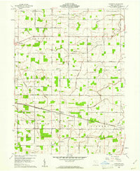
 1960 Mendon1961 Print · USGSMercer and Van Wert counties are captured in the early 1960s, showing a landscape of productive farmsteads and rural crossroads. Local researchers can trace the New York Central rail line through Mendon or locate family sites like Frisinger Cem and Wesley Chapel.2 unique versions available
 - 1960 Map of Rockford, 1961 Print
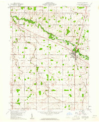 1960 Rockford1961 Print · USGSMercer and Van Wert counties are captured here at the start of the sixties, showcasing a landscape defined by the St Marys River and a busy rail junction. Genealogists can trace family names through landmarks like Riverside Cem, Fountain Chapel Cem, and the rural Bursville settlement.
 - 1960 Map of Elgin, 1961 Print
 1960 Elgin1961 Print · USGSWestern Ohio farmland is captured here in the early sixties at the meeting point of four counties. Genealogists and historians can trace family-named landmarks like Fissel Lauth Cem and Hankin Cem or locate the village of Elgin along the Erie Lackawanna Railroad.
 - 1960 Map of Van Wert, 1961 Print
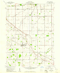
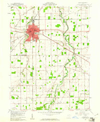
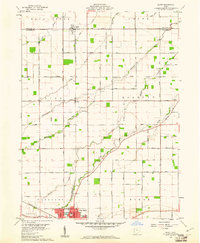
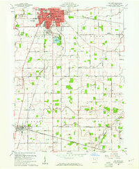 1960 Van Wert1961 Print · USGSVan Wert and its surrounding townships are shown here in the early sixties at a peak of rail and road connectivity. Genealogists can trace family names through rural sites like Wallick Cem, St Peters Ch, and the small community of Jonestown.3 unique versions available
 - 1960 Map of Glenmore, 1961 Print
 1960 Glenmore1961 Print · USGSThe rural Van Wert County landscape during the early 1960s was an intricate network of rail lines and farming crossroads. Researchers can trace family history through sites like Balyeat Cem or follow the paths of the Erie Lackawanna Railroad through Glenmore.2 unique versions available
 - 1960 Map of Wetsel, 1961 Print
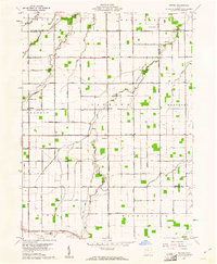 1960 Wetsel1961 Print · USGSVan Wert and Paulding Counties at the start of the 1960s show a structured rural landscape defined by straight section-line roads and family-named landmarks. Researchers can trace the exact locations of Harmony Ch, the Tri-County Airport, and small settlements like Wetsel and Seamersville.3 unique versions available
 - 1960 Map of Wren, 1962 Print
 1960 Wren1962 Print · USGSThe Indiana-Ohio borderlands at the start of the 1960s reveal a landscape defined by the St Marys River and major rail lines. Genealogists can trace family names at Old Mt Tabor Cem or locate the Covered Bridge at Pleasant Mills.3 unique versions available
 - 1960 Map of Willshire, 1964 Print
 1960 Willshire1964 Print · USGSThe Indiana-Ohio borderlands come into focus in the early sixties as a patchwork of small farms and crossroads hamlets. Genealogists and historians can locate family landmarks like Tricker Cem, Blue Creek Sch, and the riverside village of Willshire.3 unique versions available
End of results
Showing maps 1-14 of 14
Top cities of Van Wert County
- Van Wert historical maps
- Convoy historical maps
- Ohio City historical maps
- Hoaglin historical maps
- Middle Point historical maps
- Willshire historical maps
See more
Frequently asked questions
- What are the different types of historical maps available for Van Wert County?
- What is the oldest map of Van Wert County?
- Where can I purchase historical maps of Van Wert County for my home or office?
- Where can I download high-res historical maps of Van Wert County?
- Are there historical topographic maps available for Van Wert County?
- Is there historical aerial imagery available for Van Wert County?
- Where are historical maps of Van Wert County sourced from?