1950s Maps of Harveysburg, Ohio
Explore 5 historic maps of Harveysburg from the 1950s. These maps offer a rare glimpse into what life looked like during the 1950s — showing old roads, neighborhoods, homes, and landmarks that have changed or disappeared over time.
Whether you're researching your family's past, planning a metal detecting trip, or studying how Harveysburg's landscape evolved across the 1950s, these high-resolution maps are a powerful tool for exploring the history of this region.
- Focus on a specific era: All maps on this page are from the 1950s, giving you a focused view of this time period.
- See what’s changed: Compare century-old streets, trails, and buildings to today's modern landscape using overlays and satellite layers.
- Research with precision: Use these maps for genealogy, historical research, land use analysis, or educational projects.
- View, download, or print: Maps are fully viewable online in high resolution, and can be downloaded or printed for your own records.
Start exploring Harveysburg's history through authentic maps from the 1950s. This is your window into the past.
Harveysburg, OH maps
(5)- 1953 Map of Cincinnati, 1965 Print
 1953 Cincinnati1965 Print · USGSThe Ohio River valley and the industrial heartland of Indiana and Ohio are captured here during the mid-century peak of rail and river commerce. Genealogists and historians can trace connections between Cincinnati and outlying military sites like Camp Atterbury and Bakalar AFB.3 unique versions available
 - 1955 Map of New Burlington, 1956 Print
 1955 New Burlington1956 Print · USGSGreene and Clinton Counties are shown in the mid-1950s as a landscape of established townships and winding creek forks. Genealogists and local historians can trace family roots through numerous sites like New Burlington Cem, Richland Ch, and McKay Cem.2 unique versions available
 - 1955 Map of Waynesville, 1956 Print
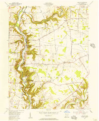
 1955 Waynesville1956 Print · USGSThe Little Miami River valley in the mid-fifties remains a landscape of small railroad hamlets and historic church communities. Genealogists and historians can trace family locations near Waynesville, Spring Valley, and the now-submerged banks of Caesar Creek.2 unique versions available
 - 1955 Map of Oregonia, 1956 Print
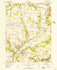
 1955 Oregonia1956 Print · USGSWarren County at the dawn of the interstate era still revolves around the river valley and its rail connections. Researchers can trace ancestral locations at Mathers Mills, Harveysburg, and local landmarks like Olive Branch Ch.2 unique versions available
 - 1957 Map of Cincinnati
 1957 Cincinnati1957 Print · USGSThe Ohio River valley and its surrounding highlands thrived during the mid-fifties industrial peak, centered on the bustling Cincinnati and Dayton metropolitan hubs. Researchers can trace the extensive rail networks and military sites like Wright-Patterson AFB and Camp Atterbury.
End of results
Showing maps 1-5 of 5
Top cities near Harveysburg
- Dayton historical maps
- Kettering historical maps
- Beavercreek historical maps
- Xenia historical maps
- Centerville historical maps
- Lebanon historical maps
See more
Frequently asked questions
- What are the different types of historical maps available for Harveysburg?
- What is the oldest map of Harveysburg?
- Where can I purchase historical maps of Harveysburg for my home or office?
- Where can I download high-res historical maps of Harveysburg?
- Are there historical topographic maps available for Harveysburg?
- Is there historical aerial imagery available for Harveysburg?
- Where are historical maps of Harveysburg sourced from?