1990s Maps of Heslop, Ohio
Explore 1 historic maps of Heslop from the 1990s. These maps offer a rare glimpse into what life looked like during the 1990s — showing old roads, neighborhoods, homes, and landmarks that have changed or disappeared over time.
Whether you're researching your family's past, planning a metal detecting trip, or studying how Heslop's landscape evolved across the 1990s, these high-resolution maps are a powerful tool for exploring the history of this region.
- Focus on a specific era: All maps on this page are from the 1990s, giving you a focused view of this time period.
- See what’s changed: Compare century-old streets, trails, and buildings to today's modern landscape using overlays and satellite layers.
- Research with precision: Use these maps for genealogy, historical research, land use analysis, or educational projects.
- View, download, or print: Maps are fully viewable online in high resolution, and can be downloaded or printed for your own records.
Start exploring Heslop's history through authentic maps from the 1990s. This is your window into the past.
Heslop, OH maps
(1)- 1994 Map of Dalzell, 1998 Print
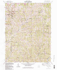 1994 Dalzell1998 Print · USGSSoutheast Ohio's deeply wooded ridges and hollows appear in the 1990s as a landscape of small hamlets and resource extraction. Genealogists can trace family names and local landmarks at Masterton Cem, Waxler Ch, and the settlement of Germantown.
End of results
Showing maps 1-1 of 1
Top cities near Heslop
- Parkersburg historical maps
- Marietta historical maps
- Vienna historical maps
- Williamstown historical maps
- Newport historical maps
- Caldwell historical maps
See more
Frequently asked questions
- What are the different types of historical maps available for Heslop?
- What is the oldest map of Heslop?
- Where can I purchase historical maps of Heslop for my home or office?
- Where can I download high-res historical maps of Heslop?
- Are there historical topographic maps available for Heslop?
- Is there historical aerial imagery available for Heslop?
- Where are historical maps of Heslop sourced from?