1990s Maps of Paint Township, Ohio
Explore 2 historic maps of Paint Township from the 1990s. These maps offer a rare glimpse into what life looked like during the 1990s — showing old roads, neighborhoods, homes, and landmarks that have changed or disappeared over time.
Whether you're researching your family's past, planning a metal detecting trip, or studying how Paint Township's landscape evolved across the 1990s, these high-resolution maps are a powerful tool for exploring the history of this region.
- Focus on a specific era: All maps on this page are from the 1990s, giving you a focused view of this time period.
- See what’s changed: Compare century-old streets, trails, and buildings to today's modern landscape using overlays and satellite layers.
- Research with precision: Use these maps for genealogy, historical research, land use analysis, or educational projects.
- View, download, or print: Maps are fully viewable online in high resolution, and can be downloaded or printed for your own records.
Start exploring Paint Township's history through authentic maps from the 1990s. This is your window into the past.
Paint Township, OH maps
(2)- 1994 Map of Wilmot, 1998 Print
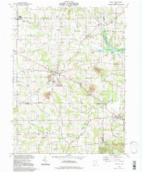 1994 Wilmot1998 Print · USGSThe rural crossroads of Wayne, Stark, and Holmes counties are captured here in the late twentieth century. Genealogists and local historians can trace family-named sites like Hershberger Cem, Beidler Sch, and the settlements of Mount Eaton and Wilmot.
 - 1994 Map of Fredricksburg, 1998 Print
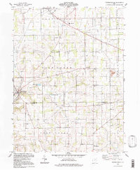 1994 Fredricksburg1998 Print · USGSWayne and Holmes counties appear in the mid-1990s, showcasing a landscape of small townships and rural school districts. Genealogists can trace family landmarks and community hubs like Fredericksburg, Calamoutier, and the Dublin Sch.
End of results
Showing maps 1-2 of 2
Top cities near Paint Township
- Massillon historical maps
- Green historical maps
- Wooster historical maps
- New Philadelphia historical maps
- New Franklin historical maps
- Dover historical maps
See more
Top neighborhoods of Paint Township
Frequently asked questions
- What are the different types of historical maps available for Paint Township?
- What is the oldest map of Paint Township?
- Where can I purchase historical maps of Paint Township for my home or office?
- Where can I download high-res historical maps of Paint Township?
- Are there historical topographic maps available for Paint Township?
- Is there historical aerial imagery available for Paint Township?
- Where are historical maps of Paint Township sourced from?